

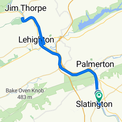
Slatington to Jim Thorpe, PA
A cycling route starting in Walnutport, Pennsylvania, United States.
Overview
About this route
- Updated Route 7/31/2021
- -:--
- Duration
- 21.8 km
- Distance
- 127 m
- Ascent
- 78 m
- Descent
- ---
- Avg. speed
- 164 m
- Max. altitude

Route quality
Waytypes & surfaces along the route
Waytypes
Cycleway
19.6 km
(90 %)
Quiet road
1.2 km
(6 %)
Surfaces
Paved
2.7 km
(13 %)
Unpaved
18.8 km
(86 %)
Gravel
18.8 km
(86 %)
Asphalt
2.5 km
(11 %)
Continue with Bikemap
Use, edit, or download this cycling route
You would like to ride Slatington to Jim Thorpe, PA or customize it for your own trip? Here is what you can do with this Bikemap route:
Free features
- Save this route as favorite or in collections
- Copy & plan your own version of this route
- Sync your route with Garmin or Wahoo
Premium features
Free trial for 3 days, or one-time payment. More about Bikemap Premium.
- Navigate this route on iOS & Android
- Export a GPX / KML file of this route
- Create your custom printout (try it for free)
- Download this route for offline navigation
Discover more Premium features.
Get Bikemap PremiumFrom our community
Other popular routes starting in Walnutport
 Slow ride in Slatington
- Distance
- 20.2 km
- Ascent
- 94 m
- Descent
- 94 m
- Location
- Walnutport, Pennsylvania, United States
 D-L Trail, Slatington to D-L Trail, Slatington
- Distance
- 50 km
- Ascent
- 803 m
- Descent
- 805 m
- Location
- Walnutport, Pennsylvania, United States
 D & L Trail, Slatington to D & L Trail, Slatington
- Distance
- 19.4 km
- Ascent
- 300 m
- Descent
- 302 m
- Location
- Walnutport, Pennsylvania, United States
 South Railroad Street 140, Slatington to Cove Road 5974, Laurys Station
- Distance
- 7.9 km
- Ascent
- 54 m
- Descent
- 63 m
- Location
- Walnutport, Pennsylvania, United States
 81–87 Main St, Slatington to 21–71 Main St, Slatington
- Distance
- 32.2 km
- Ascent
- 1,710 m
- Descent
- 1,697 m
- Location
- Walnutport, Pennsylvania, United States
 North Railroad Street 135, Slatington to West Bowmans Road 57, Lehighton
- Distance
- 9.9 km
- Ascent
- 26 m
- Descent
- 7 m
- Location
- Walnutport, Pennsylvania, United States
 21–71 Main St, Slatington to 21–71 Main St, Slatington
- Distance
- 32.3 km
- Ascent
- 1,340 m
- Descent
- 1,323 m
- Location
- Walnutport, Pennsylvania, United States
 D&l Trail, Slatington to 123 Lehigh Dr, Lehighton
- Distance
- 17.4 km
- Ascent
- 295 m
- Descent
- 264 m
- Location
- Walnutport, Pennsylvania, United States
Open it in the app