

Pri strelnici 1781 do Slovensko
A cycling route starting in Levoča, Prešov Region, Slovakia.
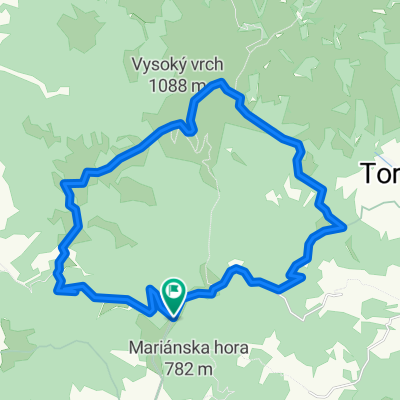
Overview
About this route
- 5 h 42 min
- Duration
- 60.3 km
- Distance
- 1,232 m
- Ascent
- 1,110 m
- Descent
- 10.6 km/h
- Avg. speed
- 1,199 m
- Max. altitude

Route photos


Route quality
Waytypes & surfaces along the route
Waytypes
Track
20.5 km
(34 %)
Quiet road
15.1 km
(25 %)
Surfaces
Paved
24.7 km
(41 %)
Unpaved
15.1 km
(25 %)
Asphalt
22.9 km
(38 %)
Gravel
13.3 km
(22 %)
Continue with Bikemap
Use, edit, or download this cycling route
You would like to ride Pri strelnici 1781 do Slovensko or customize it for your own trip? Here is what you can do with this Bikemap route:
Free features
- Save this route as favorite or in collections
- Copy & plan your own version of this route
- Sync your route with Garmin or Wahoo
Premium features
Free trial for 3 days, or one-time payment. More about Bikemap Premium.
- Navigate this route on iOS & Android
- Export a GPX / KML file of this route
- Create your custom printout (try it for free)
- Download this route for offline navigation
Discover more Premium features.
Get Bikemap PremiumFrom our community
Other popular routes starting in Levoča
 Levoča-Úloža-Závada-Javorina-Gehuľa-Brezová-Levoča
- Distance
- 43.3 km
- Ascent
- 953 m
- Descent
- 952 m
- Location
- Levoča, Prešov Region, Slovakia
 Levoča do Šarišské Bohdanovce
- Distance
- 232.2 km
- Ascent
- 2,289 m
- Descent
- 2,691 m
- Location
- Levoča, Prešov Region, Slovakia
 zrúcanina chaty Sklenár
- Distance
- 34.4 km
- Ascent
- 816 m
- Descent
- 743 m
- Location
- Levoča, Prešov Region, Slovakia
 VACLAVAK
- Distance
- 27.2 km
- Ascent
- 642 m
- Descent
- 641 m
- Location
- Levoča, Prešov Region, Slovakia
 Levocska dolina
- Distance
- 52.9 km
- Ascent
- 999 m
- Descent
- 997 m
- Location
- Levoča, Prešov Region, Slovakia
 Levoča-Danišovce-SNV -Šulerloch -Koš.Briežok
- Distance
- 60.3 km
- Ascent
- 1,223 m
- Descent
- 1,220 m
- Location
- Levoča, Prešov Region, Slovakia
 Kratučký výjazdik
- Distance
- 14.2 km
- Ascent
- 377 m
- Descent
- 380 m
- Location
- Levoča, Prešov Region, Slovakia
 49.019° N 20.494° W až 49.019° N 20.499° W
- Distance
- 17.7 km
- Ascent
- 536 m
- Descent
- 523 m
- Location
- Levoča, Prešov Region, Slovakia
Open it in the app