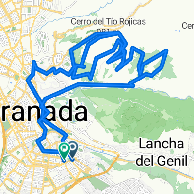
Sacromonte - Ermita de AlmezĂ - Canal de los franceses
A cycling route starting in Huétor Vega, Andalusia, Spain.
Overview
About this route
- -:--
- Duration
- 29.7 km
- Distance
- 560 m
- Ascent
- 560 m
- Descent
- ---
- Avg. speed
- ---
- Avg. speed
Route highlights
Points of interest along the route
Point of interest after 13.8 km
Ermita del Santo Cristo de AlmezĂ. Avituallamiento
Point of interest after 22.6 km
primer puente de piedra
Point of interest after 24.4 km
Comienzo del Circuito de MTB
Point of interest after 27.6 km
Por el tunel del Serrallo
Continue with Bikemap
Use, edit, or download this cycling route
You would like to ride Sacromonte - Ermita de AlmezĂ - Canal de los franceses or customize it for your own trip? Here is what you can do with this Bikemap route:
Free features
- Save this route as favorite or in collections
- Copy & plan your own version of this route
- Sync your route with Garmin or Wahoo
Premium features
Free trial for 3 days, or one-time payment. More about Bikemap Premium.
- Navigate this route on iOS & Android
- Export a GPX / KML file of this route
- Create your custom printout (try it for free)
- Download this route for offline navigation
Discover more Premium features.
Get Bikemap PremiumFrom our community
Other popular routes starting in Huétor Vega
- Embalse de Canales
- Distance
- 30.8 km
- Ascent
- 565 m
- Descent
- 566 m
- Location
- Huétor Vega, Andalusia, Spain
- GR-Gojar-Ermita Vieja-Dilar-Gojar-GR
- Distance
- 38.8 km
- Ascent
- 797 m
- Descent
- 798 m
- Location
- Huétor Vega, Andalusia, Spain
- Llano de La Perdiz-TK005
- Distance
- 27.3 km
- Ascent
- 482 m
- Descent
- 482 m
- Location
- Huétor Vega, Andalusia, Spain
- Canal de La Espartera-TK004
- Distance
- 26.4 km
- Ascent
- 805 m
- Descent
- 626 m
- Location
- Huétor Vega, Andalusia, Spain
- Barranco de San Juan
- Distance
- 23.3 km
- Ascent
- 703 m
- Descent
- 248 m
- Location
- Huétor Vega, Andalusia, Spain
- GR251 - Cueva del Agua - Yedra - 31/01/10Âș
- Distance
- 42.1 km
- Ascent
- 976 m
- Descent
- 985 m
- Location
- Huétor Vega, Andalusia, Spain
- Los cahorros Monachil - Camino de los leñeros
- Distance
- 26.2 km
- Ascent
- 702 m
- Descent
- 699 m
- Location
- Huétor Vega, Andalusia, Spain
- Los Cahorros de Monachil-TK001
- Distance
- 23.3 km
- Ascent
- 506 m
- Descent
- 508 m
- Location
- Huétor Vega, Andalusia, Spain
Open it in the app