- 76.1 km
- 574 m
- 574 m
- Lochmaben, Scotland, United Kingdom
Lockerbie, Sheildhill, Torthorwald, Dalton
A cycling route starting in Lochmaben, Scotland, United Kingdom.
Overview
About this route
Fairly easy pedalling BUT do it anti-clockwise to enjoy a very steep downhill between A75 and Dalton! I have never climbed it clockwise - ain't gonna try. ONLY 200meters on A75 - BUT this is a trunk road, BEWARE - again, safest doing it anti-clockwise. Otherwise minor, quiet country roads. Cafe near Dalton (Art Cafe/Pottery) and shops pubs at Lockerbie, which also has rain access. Torthorwald hotel has wonky hours, don't rely on it. A quiet B road bisects this loop (Templand to Dalton via Lochmaben) if you fancy shortening it
- -:--
- Duration
- 43.9 km
- Distance
- 307 m
- Ascent
- 310 m
- Descent
- ---
- Avg. speed
- ---
- Max. altitude
created this 14 years ago
Route quality
Waytypes & surfaces along the route
Waytypes
Road
36.4 km
(83 %)
Quiet road
3.1 km
(7 %)
Undefined
4.4 km
(10 %)
Surfaces
Paved
0.4 km
(1 %)
Asphalt
0.4 km
(1 %)
Undefined
43.4 km
(99 %)
Continue with Bikemap
Use, edit, or download this cycling route
You would like to ride Lockerbie, Sheildhill, Torthorwald, Dalton or customize it for your own trip? Here is what you can do with this Bikemap route:
Free features
- Save this route as favorite or in collections
- Copy & plan your own version of this route
- Sync your route with Garmin or Wahoo
Premium features
Free trial for 3 days, or one-time payment. More about Bikemap Premium.
- Navigate this route on iOS & Android
- Export a GPX / KML file of this route
- Create your custom printout (try it for free)
- Download this route for offline navigation
Discover more Premium features.
Get Bikemap PremiumFrom our community
Other popular routes starting in Lochmaben
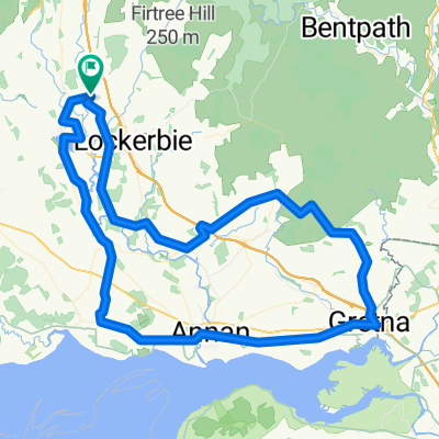
- Yettholme Cottage - Wamphray - Boreland - Eskdalemuir - Castle O'er - Lockerbie - Yettholme
- Millhouse', Shieldhill, T'th'wald, M'wald, Dalton, Scroggs Bridge return
- 58.5 km
- 329 m
- 329 m
- Lochmaben, Scotland, United Kingdom
- 'Fechan, W'beck, Chapelknowe, Gretna, Annan, Lochmaben
- 91.2 km
- 266 m
- 264 m
- Lochmaben, Scotland, United Kingdom
- LEJOG 2010 - Stage Eight
- 167.9 km
- 562 m
- 636 m
- Lochmaben, Scotland, United Kingdom
- Mid Annandale, Canonbie, Catlowdy, Carlisle, Gretna and return
- 130.3 km
- 439 m
- 439 m
- Lochmaben, Scotland, United Kingdom
- 06 vanaf Lochmaben
- 71.7 km
- 604 m
- 442 m
- Lochmaben, Scotland, United Kingdom
- Millhousebridge-SamyeLing-Waterbeck-(Brydekirk)-Kettleholm-Lockerbie-Millhousebridge
- 88.7 km
- 470 m
- 472 m
- Lochmaben, Scotland, United Kingdom
- Lockerbie,Langholm, Canonbie,'Fechan,Applegarth
- 90 km
- 497 m
- 497 m
- Lochmaben, Scotland, United Kingdom
Open it in the app


