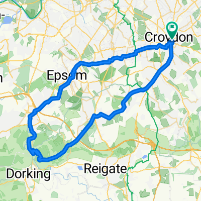
680 Purley Way, Croydon to Brighton Railway Station, Queen's Road, Brighton
A cycling route starting in South Croydon, England, United Kingdom.
Overview
About this route
- 4 h 4 min
- Duration
- 70 km
- Distance
- 359 m
- Ascent
- 380 m
- Descent
- 17.2 km/h
- Avg. speed
- 152 m
- Max. altitude
Continue with Bikemap
Use, edit, or download this cycling route
You would like to ride 680 Purley Way, Croydon to Brighton Railway Station, Queen's Road, Brighton or customize it for your own trip? Here is what you can do with this Bikemap route:
Free features
- Save this route as favorite or in collections
- Copy & plan your own version of this route
- Sync your route with Garmin or Wahoo
Premium features
Free trial for 3 days, or one-time payment. More about Bikemap Premium.
- Navigate this route on iOS & Android
- Export a GPX / KML file of this route
- Create your custom printout (try it for free)
- Download this route for offline navigation
Discover more Premium features.
Get Bikemap PremiumFrom our community
Other popular routes starting in South Croydon
- South Croydon, Botley Godstone, Merstham, Chipstead Loop
- Distance
- 54.4 km
- Ascent
- 526 m
- Descent
- 526 m
- Location
- South Croydon, England, United Kingdom
- Croydon to Greenwich ( Via Cycle Route 21)
- Distance
- 17.8 km
- Ascent
- 4 m
- Descent
- 83 m
- Location
- South Croydon, England, United Kingdom
- East Croydon - Botley Hill 37KM
- Distance
- 36.7 km
- Ascent
- 373 m
- Descent
- 369 m
- Location
- South Croydon, England, United Kingdom
- Figure of 8
- Distance
- 29.5 km
- Ascent
- 330 m
- Descent
- 330 m
- Location
- South Croydon, England, United Kingdom
- Road-Biggin Hill & Boxhill from East Croydon
- Distance
- 96.7 km
- Ascent
- 693 m
- Descent
- 693 m
- Location
- South Croydon, England, United Kingdom
- London-Crydon nach Dover
- Distance
- 140.6 km
- Ascent
- 1,047 m
- Descent
- 1,038 m
- Location
- South Croydon, England, United Kingdom
- South Croydon, Banstead, Box Hill, Reigate Loop
- Distance
- 62.8 km
- Ascent
- 509 m
- Descent
- 509 m
- Location
- South Croydon, England, United Kingdom
- Purley Way 403A to Ship Street
- Distance
- 57.7 km
- Ascent
- 455 m
- Descent
- 373 m
- Location
- South Croydon, England, United Kingdom
Open it in the app