

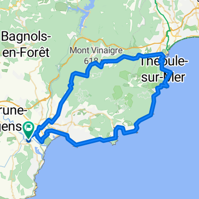
St.Aygulf - Esterel - Mandelieu - Lac St. Cassien - St.Aygulf
A cycling route starting in Fréjus, Provence-Alpes-Côte d'Azur Region, France.
Overview
About this route
- -:--
- Duration
- 89.4 km
- Distance
- 2,486 m
- Ascent
- 2,404 m
- Descent
- ---
- Avg. speed
- 466 m
- Max. altitude

Route quality
Waytypes & surfaces along the route
Waytypes
Road
23.2 km
(26 %)
Quiet road
4.5 km
(5 %)
Surfaces
Paved
42 km
(47 %)
Unpaved
2.7 km
(3 %)
Asphalt
42 km
(47 %)
Ground
1.8 km
(2 %)
Continue with Bikemap
Use, edit, or download this cycling route
You would like to ride St.Aygulf - Esterel - Mandelieu - Lac St. Cassien - St.Aygulf or customize it for your own trip? Here is what you can do with this Bikemap route:
Free features
- Save this route as favorite or in collections
- Copy & plan your own version of this route
- Split it into stages to create a multi-day tour
- Sync your route with Garmin or Wahoo
Premium features
Free trial for 3 days, or one-time payment. More about Bikemap Premium.
- Navigate this route on iOS & Android
- Export a GPX / KML file of this route
- Create your custom printout (try it for free)
- Download this route for offline navigation
Discover more Premium features.
Get Bikemap PremiumFrom our community
Other popular routes starting in Fréjus
 Frejus 71km 1380hm
- Distance
- 71.6 km
- Ascent
- 1,386 m
- Descent
- 1,384 m
- Location
- Fréjus, Provence-Alpes-Côte d'Azur Region, France
 Nördlich von Fréjus
- Distance
- 48.3 km
- Ascent
- 905 m
- Descent
- 905 m
- Location
- Fréjus, Provence-Alpes-Côte d'Azur Region, France
 Frejus 56km 1400hm
- Distance
- 56.5 km
- Ascent
- 1,458 m
- Descent
- 1,457 m
- Location
- Fréjus, Provence-Alpes-Côte d'Azur Region, France
 Frejus to MPL
- Distance
- 33.4 km
- Ascent
- 1,334 m
- Descent
- 1,333 m
- Location
- Fréjus, Provence-Alpes-Côte d'Azur Region, France
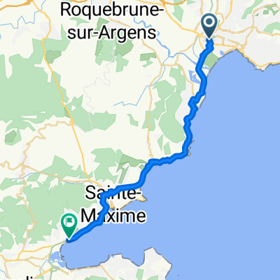 Les Mures, Grimaud nach Rue Montgolfier, Fréjus
- Distance
- 27.5 km
- Ascent
- 230 m
- Descent
- 239 m
- Location
- Fréjus, Provence-Alpes-Côte d'Azur Region, France
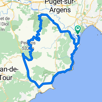
 Tour de l'Estérel
- Distance
- 63.3 km
- Ascent
- 579 m
- Descent
- 579 m
- Location
- Fréjus, Provence-Alpes-Côte d'Azur Region, France
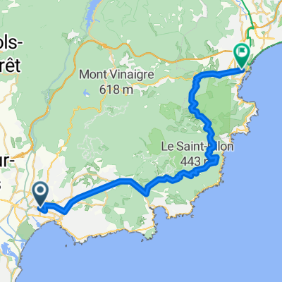
 S Frankreich 1. Tag
- Distance
- 58.1 km
- Ascent
- 511 m
- Descent
- 511 m
- Location
- Fréjus, Provence-Alpes-Côte d'Azur Region, France
 St.Aygulf - Esterel - Mandelieu - Lac St. Cassien - St.Aygulf
- Distance
- 89.4 km
- Ascent
- 2,486 m
- Descent
- 2,404 m
- Location
- Fréjus, Provence-Alpes-Côte d'Azur Region, France
Open it in the app