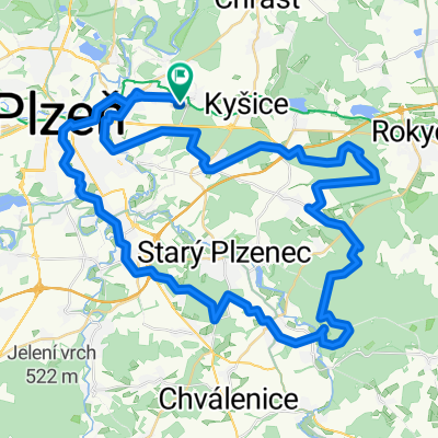
Přes 7 vrcholů plzeňska
A cycling route starting in Dýšina, Plzeň Region, Czechia.
Overview
About this route
Loop over 7 peaks of the Pilsen region (Radyně, Maršál, Žďár, Trhoň, Radeč, Krkavec, Chlum). Start and finish in Červený Hrádek.
- -:--
- Duration
- 105.1 km
- Distance
- 1,473 m
- Ascent
- 1,473 m
- Descent
- ---
- Avg. speed
- ---
- Max. altitude
Continue with Bikemap
Use, edit, or download this cycling route
You would like to ride Přes 7 vrcholů plzeňska or customize it for your own trip? Here is what you can do with this Bikemap route:
Free features
- Save this route as favorite or in collections
- Copy & plan your own version of this route
- Split it into stages to create a multi-day tour
- Sync your route with Garmin or Wahoo
Premium features
Free trial for 3 days, or one-time payment. More about Bikemap Premium.
- Navigate this route on iOS & Android
- Export a GPX / KML file of this route
- Create your custom printout (try it for free)
- Download this route for offline navigation
Discover more Premium features.
Get Bikemap PremiumFrom our community
Other popular routes starting in Dýšina
- okruh Červený Hrádek - Kokotsko
- Distance
- 26.3 km
- Ascent
- 470 m
- Descent
- 470 m
- Location
- Dýšina, Plzeň Region, Czechia
- okolo Berounky
- Distance
- 19.4 km
- Ascent
- 280 m
- Descent
- 279 m
- Location
- Dýšina, Plzeň Region, Czechia
- Červený Hrádek - okolo Berounky - Červený Hrádek
- Distance
- 23 km
- Ascent
- 285 m
- Descent
- 285 m
- Location
- Dýšina, Plzeň Region, Czechia
- Červený Hrádek, Rokycany, Dobřív, Holoubkov, Volduchy, Osek, Kokotské rybníky, Kyšice, Červený Hrádek
- Distance
- 63.5 km
- Ascent
- 626 m
- Descent
- 625 m
- Location
- Dýšina, Plzeň Region, Czechia
- Červený Hrádek, Padrťské rybníky, Červený Hrádek
- Distance
- 99 km
- Ascent
- 829 m
- Descent
- 826 m
- Location
- Dýšina, Plzeň Region, Czechia
- Dětzská trasa II. (Radobyčice, Hradiště)
- Distance
- 36 km
- Ascent
- 310 m
- Descent
- 310 m
- Location
- Dýšina, Plzeň Region, Czechia
- Lipovka, Krkavec (po zelené)
- Distance
- 64.9 km
- Ascent
- 589 m
- Descent
- 593 m
- Location
- Dýšina, Plzeň Region, Czechia
- Červený Hrádek, podél Berounky, přírodní park Radeč, Červený Hrádek
- Distance
- 68 km
- Ascent
- 817 m
- Descent
- 814 m
- Location
- Dýšina, Plzeň Region, Czechia
Open it in the app