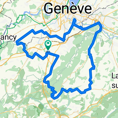
Mont Saleve Huts
A cycling route starting in Neydens, Auvergne-Rh么ne-Alpes, France.
Overview
About this route
- -:--
- Duration
- 15.9 km
- Distance
- 320 m
- Ascent
- 319 m
- Descent
- ---
- Avg. speed
- 886 m
- Avg. speed
Route quality
Waytypes & surfaces along the route
Waytypes
Road
5.3 km
(34 %)
Quiet road
4.1 km
(25 %)
Surfaces
Paved
6.3 km
(39 %)
Unpaved
2.8 km
(17 %)
Asphalt
6.3 km
(39 %)
Gravel
2.1 km
(13 %)
Route highlights
Points of interest along the route
Point of interest after 6.1 km
Col du Mont Sion
Point of interest after 8 km
Rejoin paved road
Point of interest after 8.3 km
Brief Paved stretch
Point of interest after 8.9 km
Great trails, alternated to paved road
Point of interest after 12.1 km
Grotte du Diable
Point of interest after 12.6 km
Col des Pitons
Point of interest after 15.2 km
Vue des Alpes
Point of interest after 15.2 km
Col de la Croisett
Point of interest after 15.2 km
Trails with Geneva view
Continue with Bikemap
Use, edit, or download this cycling route
You would like to ride Mont Saleve Huts or customize it for your own trip? Here is what you can do with this Bikemap route:
Free features
- Save this route as favorite or in collections
- Copy & plan your own version of this route
- Sync your route with Garmin or Wahoo
Premium features
Free trial for 3 days, or one-time payment. More about Bikemap Premium.
- Navigate this route on iOS & Android
- Export a GPX / KML file of this route
- Create your custom printout (try it for free)
- Download this route for offline navigation
Discover more Premium features.
Get Bikemap PremiumFrom our community
Other popular routes starting in Neydens
- Saleve via Col des Pitons
- Distance
- 35.6 km
- Ascent
- 979 m
- Descent
- 952 m
- Location
- Neydens, Auvergne-Rh么ne-Alpes, France
- Circuit Neydens - Valleiry 48 km
- Distance
- 48.5 km
- Ascent
- 709 m
- Descent
- 709 m
- Location
- Neydens, Auvergne-Rh么ne-Alpes, France
- Stef@ns Tour zur Tour 2004 3. Etappe Teil 1 vom 18.07.04
- Distance
- 85.2 km
- Ascent
- 589 m
- Descent
- 875 m
- Location
- Neydens, Auvergne-Rh么ne-Alpes, France
- Saleve Snow Loop
- Distance
- 39.2 km
- Ascent
- 932 m
- Descent
- 898 m
- Location
- Neydens, Auvergne-Rh么ne-Alpes, France
- Mont Saleve 1
- Distance
- 33.7 km
- Ascent
- 836 m
- Descent
- 837 m
- Location
- Neydens, Auvergne-Rh么ne-Alpes, France
- Five Country Loop
- Distance
- 64.8 km
- Ascent
- 589 m
- Descent
- 589 m
- Location
- Neydens, Auvergne-Rh么ne-Alpes, France
- Le Saleve
- Distance
- 26.1 km
- Ascent
- 1,019 m
- Descent
- 975 m
- Location
- Neydens, Auvergne-Rh么ne-Alpes, France
- Mont Sal猫ve Snow Trails
- Distance
- 40.7 km
- Ascent
- 932 m
- Descent
- 934 m
- Location
- Neydens, Auvergne-Rh么ne-Alpes, France
Open it in the app