

Overview
About this route
Long river and villages
- -:--
- Duration
- 36 km
- Distance
- 115 m
- Ascent
- 113 m
- Descent
- ---
- Avg. speed
- 70 m
- Max. altitude

Part of
Frankrijk
1 stage
Route quality
Waytypes & surfaces along the route
Waytypes
Quiet road
10.1 km
(28 %)
Track
7.9 km
(22 %)
Surfaces
Paved
14.1 km
(39 %)
Unpaved
7.9 km
(22 %)
Asphalt
13.7 km
(38 %)
Gravel
4.3 km
(12 %)
Route highlights
Points of interest along the route
Point of interest after 25.3 km
Continue with Bikemap
Use, edit, or download this cycling route
You would like to ride Le gardon Rhone or customize it for your own trip? Here is what you can do with this Bikemap route:
Free features
- Save this route as favorite or in collections
- Copy & plan your own version of this route
- Sync your route with Garmin or Wahoo
Premium features
Free trial for 3 days, or one-time payment. More about Bikemap Premium.
- Navigate this route on iOS & Android
- Export a GPX / KML file of this route
- Create your custom printout (try it for free)
- Download this route for offline navigation
Discover more Premium features.
Get Bikemap PremiumFrom our community
Other popular routes starting in Castillon-du-Gard
 De Rue Théodore Aubanel 27, Saint-Hilaire-d'Ozilhan à Rue Alphonse Tavan 3, Saint-Hilaire-d'Ozilhan
- Distance
- 10.8 km
- Ascent
- 165 m
- Descent
- 169 m
- Location
- Castillon-du-Gard, Occitanie, France
 Le gardon Rhone
- Distance
- 36 km
- Ascent
- 115 m
- Descent
- 113 m
- Location
- Castillon-du-Gard, Occitanie, France
 2009-03 Provence (France) - Pont du Gard - Gallician
- Distance
- 46.5 km
- Ascent
- 317 m
- Descent
- 322 m
- Location
- Castillon-du-Gard, Occitanie, France
 pont du gard
- Distance
- 87.1 km
- Ascent
- 923 m
- Descent
- 903 m
- Location
- Castillon-du-Gard, Occitanie, France
 Pont du Gard - Tarascon - Avignon
- Distance
- 62.4 km
- Ascent
- 196 m
- Descent
- 197 m
- Location
- Castillon-du-Gard, Occitanie, France
 BONUS Pont-du-Gard - Paradou
- Distance
- 40.6 km
- Ascent
- 314 m
- Descent
- 339 m
- Location
- Castillon-du-Gard, Occitanie, France
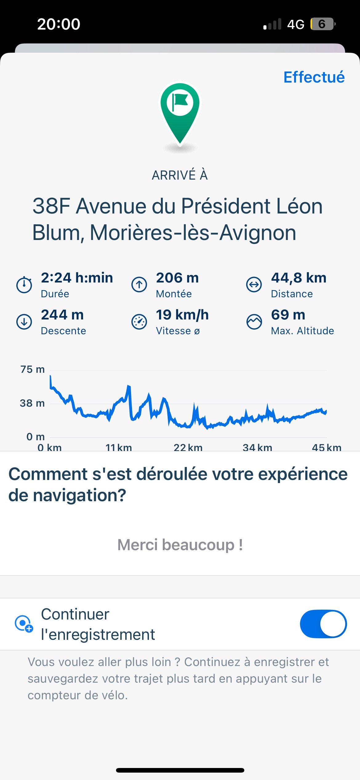 Chemin du Grès, Argilliers à Rue du Docteur S Bioules, Morières-lès-Avignon
- Distance
- 45.4 km
- Ascent
- 215 m
- Descent
- 244 m
- Location
- Castillon-du-Gard, Occitanie, France
 La Soustra aux vestiges romain de Sernhac
- Distance
- 23.3 km
- Ascent
- 164 m
- Descent
- 165 m
- Location
- Castillon-du-Gard, Occitanie, France
Open it in the app