

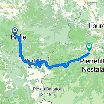
TDP - ETAPE 5
A cycling route starting in Louvie-Juzon, Nouvelle-Aquitaine, France.
Overview
About this route
- -:--
- Duration
- 67.1 km
- Distance
- 551 m
- Ascent
- 366 m
- Descent
- ---
- Avg. speed
- 622 m
- Max. altitude
Route quality
Waytypes & surfaces along the route
Waytypes
Road
21.5 km
(32 %)
Quiet road
20.8 km
(31 %)
Surfaces
Paved
35.5 km
(53 %)
Unpaved
1.3 km
(2 %)
Asphalt
35.5 km
(53 %)
Gravel
1.3 km
(2 %)
Undefined
30.2 km
(45 %)
Route highlights
Points of interest along the route
Point of interest after 0 km
BIVOUAC N°04 / + 261.2KM / 7200D+ / mardi 03.08 soir
Point of interest after 0 km
PASSERELLE D'HOLZARTE
Point of interest after 0 km
BIVOUAC N°02 / + 110KM / 3570D+ / dimanche 01.08 soir
Point of interest after 1 km
LA CHAPELLE DE3 LA MADELEINE
Point of interest after 1 km
BIVOUAC N°01 / + 40KM / 1150M D+ / samedi 31.07 soir
Point of interest after 1 km
BIVOUAC N°03 / + 181.1KM / 5040D+ / lundi 02.08 soir
Point of interest after 1 km
RAVITAILLEMENT
Point of interest after 1 km
CHAPEL DE NOTRE DAME DE L'AUBEPINE
Point of interest after 67 km
BIVOUAC N°09 / + 608.1KM / 15460D+ / dimanche 08.08 soir
Point of interest after 67 km
Tour Madeloc
Point of interest after 67 km
BIVOUAC N°12 / + 825.3KM / 19760D+ / mercredi 11.08 soir
Point of interest after 67 km
COL DU TOURMALET
Point of interest after 67 km
BIVOUAC N°07 / + 460.2KM / 11890D+ / vendredi 06.08 soir
Point of interest after 67 km
BIVOUAC N°08 / + 528.1KM / 13590D+ / samedi 07.08 soir
Point of interest after 67 km
COL DU PORTET
Point of interest after 67 km
LAC
Point of interest after 67 km
BIVOUAC N°05 / + 327.8KM / 7730D+ / mercredi 04.08 soir
Point of interest after 67 km
BIVOUAC N°06 / + 397.3KM / 9190D+ / jeudi 05.08 soir
Point of interest after 67 km
COL DE PEYRESOURDE
Point of interest after 67 km
COL D'ASPIN
Point of interest after 67 km
BIVOUAC N°11 / + 759.5KM / 18080D+ / mardi 10.08 soir
Point of interest after 67 km
Lac
Point of interest after 67 km
PIC NEULOS
Point of interest after 67 km
BIVOUAC N°10 / + 691.1KM / 16400D+ / lundi 09.08 soir
Point of interest after 67.1 km
COL LUZ ARDIDEN
Continue with Bikemap
Use, edit, or download this cycling route
You would like to ride TDP - ETAPE 5 or customize it for your own trip? Here is what you can do with this Bikemap route:
Free features
- Save this route as favorite or in collections
- Copy & plan your own version of this route
- Sync your route with Garmin or Wahoo
Premium features
Free trial for 3 days, or one-time payment. More about Bikemap Premium.
- Navigate this route on iOS & Android
- Export a GPX / KML file of this route
- Create your custom printout (try it for free)
- Download this route for offline navigation
Discover more Premium features.
Get Bikemap PremiumFrom our community
Other popular routes starting in Louvie-Juzon
 24 oktober 2020 Kinomap - ⏱️ Tissot Challenge 🚴 Pyrenees
- Distance
- 19.2 km
- Ascent
- 128 m
- Descent
- 683 m
- Location
- Louvie-Juzon, Nouvelle-Aquitaine, France
 Arudy-Col d´Abisque-Col du Soulor-Argelés Gazost- Sassis
- Distance
- 76.4 km
- Ascent
- 1,764 m
- Descent
- 1,576 m
- Location
- Louvie-Juzon, Nouvelle-Aquitaine, France
 FDs Bielle StJeandepieddeport
- Distance
- 136.7 km
- Ascent
- 3,716 m
- Descent
- 4,004 m
- Location
- Louvie-Juzon, Nouvelle-Aquitaine, France
 col de l'aubisque
- Distance
- 76.5 km
- Ascent
- 1,652 m
- Descent
- 1,654 m
- Location
- Louvie-Juzon, Nouvelle-Aquitaine, France
 Louvie-Juzon - Arudy - Aubisque - Soulor - Arthez
- Distance
- 79.8 km
- Ascent
- 2,195 m
- Descent
- 2,196 m
- Location
- Louvie-Juzon, Nouvelle-Aquitaine, France
 64260 Bilhères to Argelès-Gazost
- Distance
- 57.1 km
- Ascent
- 0 m
- Descent
- 0 m
- Location
- Louvie-Juzon, Nouvelle-Aquitaine, France
 De Rue Principale 1, Sainte-Colome à Chemin de Caille, Sainte-Colome
- Distance
- 6.8 km
- Ascent
- 195 m
- Descent
- 288 m
- Location
- Louvie-Juzon, Nouvelle-Aquitaine, France
 115km 2770d+ Louvie-Juzon
- Distance
- 114.9 km
- Ascent
- 2,062 m
- Descent
- 2,064 m
- Location
- Louvie-Juzon, Nouvelle-Aquitaine, France
Open it in the app