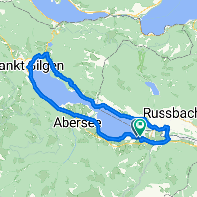
- 43.9 km
- 889 m
- 884 m
- Strobl, Salzburg, Austria
Strobl Cycling
A cycling route starting in Strobl, Salzburg, Austria.
Overview
About this route
Postalmklam. Přístup je po zaplacení mýtného. 25 euro pro obytné auto. Zato můžete nocovat vysoko nad jezerem Wolfgangsee. Je tady tolik krásných cyklotras i turistických tras, že tu můžete strávit i dva dny, zažít západ i východ slunce. Parkplatz P1 je také pro obytná auta. K dispozici jsou i toalety. Kapacita parkovišť je přispůsobená zimnímu provozu, takže v létě tu najdete vždy volné místo.
- -:--
- Duration
- 30.9 km
- Distance
- 967 m
- Ascent
- 974 m
- Descent
- ---
- Avg. speed
- 1,438 m
- Max. altitude
created this 4 years ago
Route photos
Continue with Bikemap
Use, edit, or download this cycling route
You would like to ride Strobl Cycling or customize it for your own trip? Here is what you can do with this Bikemap route:
Free features
- Save this route as favorite or in collections
- Copy & plan your own version of this route
- Sync your route with Garmin or Wahoo
Premium features
Free trial for 3 days, or one-time payment. More about Bikemap Premium.
- Navigate this route on iOS & Android
- Export a GPX / KML file of this route
- Create your custom printout (try it for free)
- Download this route for offline navigation
Discover more Premium features.
Get Bikemap PremiumFrom our community
Other popular routes starting in Strobl
- Schwarzensee
- Okolo Wolfgansee
- 42.5 km
- 955 m
- 954 m
- Strobl, Salzburg, Austria
- DI Seerundfahrt Wolfgangsee 32KM 600HM
- 32.1 km
- 797 m
- 795 m
- Strobl, Salzburg, Austria
- Bürglstraße nach Bürglstraße
- 76.9 km
- 1,601 m
- 1,601 m
- Strobl, Salzburg, Austria
- Faistenauer Schafberg
- 25.1 km
- 1,685 m
- 739 m
- Strobl, Salzburg, Austria
- Eisenaueralm & Wolfgangsee
- 40.9 km
- 644 m
- 644 m
- Strobl, Salzburg, Austria
- Schwarzensee
- 8.3 km
- 251 m
- 252 m
- Strobl, Salzburg, Austria
- Recovered Route
- 26.6 km
- 144 m
- 207 m
- Strobl, Salzburg, Austria
Open it in the app


