
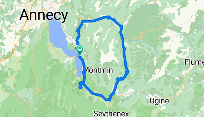
Itinéraire vers Route d'Angon 558, Talloires-Montmin
A cycling route starting in Talloires, Auvergne-Rhône-Alpes, France.
Overview
About this route
- 4 h 52 min
- Duration
- 59 km
- Distance
- 1,096 m
- Ascent
- 1,095 m
- Descent
- 12.1 km/h
- Avg. speed
- 857 m
- Max. altitude

Route quality
Waytypes & surfaces along the route
Waytypes
Busy road
27.5 km
(47 %)
Cycleway
9.5 km
(16 %)
Surfaces
Paved
32.8 km
(56 %)
Unpaved
0.4 km
(<1 %)
Asphalt
31.8 km
(54 %)
Concrete
0.5 km
(<1 %)
Continue with Bikemap
Use, edit, or download this cycling route
You would like to ride Itinéraire vers Route d'Angon 558, Talloires-Montmin or customize it for your own trip? Here is what you can do with this Bikemap route:
Free features
- Save this route as favorite or in collections
- Copy & plan your own version of this route
- Sync your route with Garmin or Wahoo
Premium features
Free trial for 3 days, or one-time payment. More about Bikemap Premium.
- Navigate this route on iOS & Android
- Export a GPX / KML file of this route
- Create your custom printout (try it for free)
- Download this route for offline navigation
Discover more Premium features.
Get Bikemap PremiumFrom our community
Other popular routes starting in Talloires
 La Résistance 125km avec détour Gravel
- Distance
- 125.1 km
- Ascent
- 4,092 m
- Descent
- 4,091 m
- Location
- Talloires, Auvergne-Rhône-Alpes, France
 Semnoz Ride
- Distance
- 70.2 km
- Ascent
- 1,416 m
- Descent
- 1,425 m
- Location
- Talloires, Auvergne-Rhône-Alpes, France
 Itinéraire vers Route d'Angon 558, Talloires-Montmin
- Distance
- 59 km
- Ascent
- 1,096 m
- Descent
- 1,095 m
- Location
- Talloires, Auvergne-Rhône-Alpes, France
 col de la forclaz, annecy
- Distance
- 9.1 km
- Ascent
- 757 m
- Descent
- 83 m
- Location
- Talloires, Auvergne-Rhône-Alpes, France
 Annecy Cols (2) Leschaux, Semnoz 120815
- Distance
- 55.7 km
- Ascent
- 1,247 m
- Descent
- 1,247 m
- Location
- Talloires, Auvergne-Rhône-Alpes, France
 Meer van Annecy + Cret de Chatillon
- Distance
- 73.3 km
- Ascent
- 1,369 m
- Descent
- 1,369 m
- Location
- Talloires, Auvergne-Rhône-Alpes, France
 Glieres, Colombiere & Croix fry
- Distance
- 119.5 km
- Ascent
- 2,648 m
- Descent
- 2,783 m
- Location
- Talloires, Auvergne-Rhône-Alpes, France
 Col de Fry and Col de Aravis 91Km
- Distance
- 92.4 km
- Ascent
- 1,675 m
- Descent
- 1,674 m
- Location
- Talloires, Auvergne-Rhône-Alpes, France
Open it in the app