

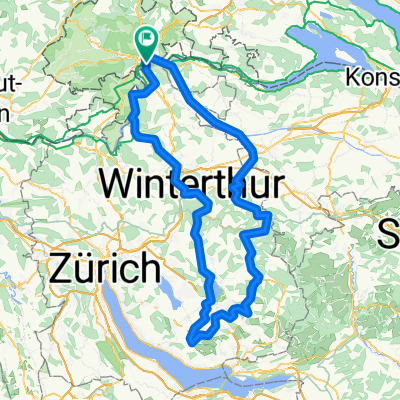
Schaffhausen - Hohentengen
A cycling route starting in Flurlingen, Canton of Zurich, Switzerland.
Overview
About this route
- -:--
- Duration
- 63.8 km
- Distance
- 339 m
- Ascent
- 336 m
- Descent
- ---
- Avg. speed
- 456 m
- Max. altitude
Route quality
Waytypes & surfaces along the route
Waytypes
Road
25.5 km
(40 %)
Quiet road
16.6 km
(26 %)
Surfaces
Paved
56.8 km
(89 %)
Unpaved
6.4 km
(10 %)
Asphalt
56.8 km
(89 %)
Gravel
3.8 km
(6 %)
Continue with Bikemap
Use, edit, or download this cycling route
You would like to ride Schaffhausen - Hohentengen or customize it for your own trip? Here is what you can do with this Bikemap route:
Free features
- Save this route as favorite or in collections
- Copy & plan your own version of this route
- Sync your route with Garmin or Wahoo
Premium features
Free trial for 3 days, or one-time payment. More about Bikemap Premium.
- Navigate this route on iOS & Android
- Export a GPX / KML file of this route
- Create your custom printout (try it for free)
- Download this route for offline navigation
Discover more Premium features.
Get Bikemap PremiumFrom our community
Other popular routes starting in Flurlingen
 Schaffhausen - Hohentengen
- Distance
- 63.8 km
- Ascent
- 339 m
- Descent
- 336 m
- Location
- Flurlingen, Canton of Zurich, Switzerland
 Schaffhausen - Rheinau dem Rhein entlang
- Distance
- 22.4 km
- Ascent
- 280 m
- Descent
- 280 m
- Location
- Flurlingen, Canton of Zurich, Switzerland
 VBS
VBS- Distance
- 50.7 km
- Ascent
- 218 m
- Descent
- 214 m
- Location
- Flurlingen, Canton of Zurich, Switzerland
 Steinam Rhein - Weinland (BH)
- Distance
- 60.3 km
- Ascent
- 513 m
- Descent
- 514 m
- Location
- Flurlingen, Canton of Zurich, Switzerland
 Wolfis-Zeitfahrrunde
- Distance
- 38.8 km
- Ascent
- 449 m
- Descent
- 449 m
- Location
- Flurlingen, Canton of Zurich, Switzerland
 Flur-Andelfingen (BH)
- Distance
- 19.5 km
- Ascent
- 116 m
- Descent
- 536 m
- Location
- Flurlingen, Canton of Zurich, Switzerland
 F-Üsslingen-Irchel (BH)
- Distance
- 72.6 km
- Ascent
- 492 m
- Descent
- 492 m
- Location
- Flurlingen, Canton of Zurich, Switzerland
 Flurlingen - Oetwil am See zurück (BH)
- Distance
- 163.2 km
- Ascent
- 1,185 m
- Descent
- 1,184 m
- Location
- Flurlingen, Canton of Zurich, Switzerland
Open it in the app