

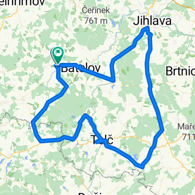
Cerekev - under Čeřínek
A cycling route starting in Horní Cerekev, Kraj Vysočina, Czechia.
Overview
About this route
24/04/2011 Mixed surface MTB ride pulling the Chariot. Again mostly road, forest and field roads with small sections of more technical trail and singletrack.
- -:--
- Duration
- 27.6 km
- Distance
- 403 m
- Ascent
- 403 m
- Descent
- ---
- Avg. speed
- ---
- Max. altitude

Route quality
Waytypes & surfaces along the route
Waytypes
Track
16.8 km
(61 %)
Quiet road
2.2 km
(8 %)
Surfaces
Paved
6.6 km
(24 %)
Unpaved
8.8 km
(32 %)
Asphalt
6.1 km
(22 %)
Gravel
3.9 km
(14 %)
Route highlights
Points of interest along the route
Point of interest after 3.8 km
narrow rooted singletrack
Continue with Bikemap
Use, edit, or download this cycling route
You would like to ride Cerekev - under Čeřínek or customize it for your own trip? Here is what you can do with this Bikemap route:
Free features
- Save this route as favorite or in collections
- Copy & plan your own version of this route
- Sync your route with Garmin or Wahoo
Premium features
Free trial for 3 days, or one-time payment. More about Bikemap Premium.
- Navigate this route on iOS & Android
- Export a GPX / KML file of this route
- Create your custom printout (try it for free)
- Download this route for offline navigation
Discover more Premium features.
Get Bikemap PremiumFrom our community
Other popular routes starting in Horní Cerekev
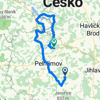
 Cerekev - Křemešník
- Distance
- 28.9 km
- Ascent
- 420 m
- Descent
- 420 m
- Location
- Horní Cerekev, Kraj Vysočina, Czechia
 H.Cerekev-S.Říše
- Distance
- 109.1 km
- Ascent
- 767 m
- Descent
- 772 m
- Location
- Horní Cerekev, Kraj Vysočina, Czechia
 Kolečko Hříběcí-Počátky-Horní Cerekev
- Distance
- 35.3 km
- Ascent
- 329 m
- Descent
- 327 m
- Location
- Horní Cerekev, Kraj Vysočina, Czechia
 Cerekev - under Čeřínek
- Distance
- 27.6 km
- Ascent
- 403 m
- Descent
- 403 m
- Location
- Horní Cerekev, Kraj Vysočina, Czechia
 Horní cereke- zvůle
- Distance
- 74.2 km
- Ascent
- 741 m
- Descent
- 738 m
- Location
- Horní Cerekev, Kraj Vysočina, Czechia
 opiop
opiop- Distance
- 99.4 km
- Ascent
- 747 m
- Descent
- 872 m
- Location
- Horní Cerekev, Kraj Vysočina, Czechia
 Cerekev, St. Kate, under Javorice and back
- Distance
- 31.9 km
- Ascent
- 490 m
- Descent
- 492 m
- Location
- Horní Cerekev, Kraj Vysočina, Czechia
 od lomu v Cerekvi
- Distance
- 103.4 km
- Ascent
- 872 m
- Descent
- 872 m
- Location
- Horní Cerekev, Kraj Vysočina, Czechia
Open it in the app