
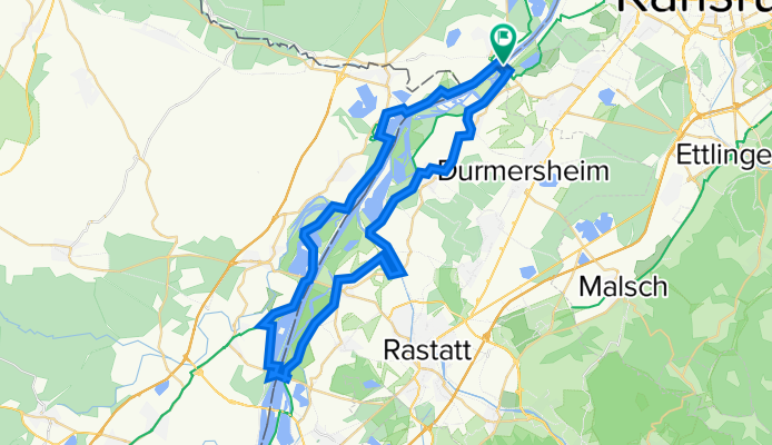
Rheinstetten rheinaufwärts bis Beinheim
A cycling route starting in Neuburg, Rhineland-Palatinate, Germany.
Overview
About this route
Rheinstetten - Neuburgsweiler ferry over the Rhine - (passing the Pittersdorf ferry) - Beinheim - Wintersdorf Rhine bridge over the Rhine to Wintersdorf - return to Rheinstetten
- -:--
- Duration
- 50.6 km
- Distance
- 30 m
- Ascent
- 31 m
- Descent
- ---
- Avg. speed
- 119 m
- Max. altitude
Route quality
Waytypes & surfaces along the route
Waytypes
Track
30.4 km
(60 %)
Cycleway
6.1 km
(12 %)
Surfaces
Paved
34.4 km
(68 %)
Unpaved
14.2 km
(28 %)
Asphalt
31.4 km
(62 %)
Gravel
7.6 km
(15 %)
Continue with Bikemap
Use, edit, or download this cycling route
You would like to ride Rheinstetten rheinaufwärts bis Beinheim or customize it for your own trip? Here is what you can do with this Bikemap route:
Free features
- Save this route as favorite or in collections
- Copy & plan your own version of this route
- Sync your route with Garmin or Wahoo
Premium features
Free trial for 3 days, or one-time payment. More about Bikemap Premium.
- Navigate this route on iOS & Android
- Export a GPX / KML file of this route
- Create your custom printout (try it for free)
- Download this route for offline navigation
Discover more Premium features.
Get Bikemap PremiumFrom our community
Other popular routes starting in Neuburg
 RR-Tour aus Rheinstetten zur Festungstadt Bitsche im Nordelsaß und zurück.
- Distance
- 169.7 km
- Ascent
- 547 m
- Descent
- 545 m
- Location
- Neuburg, Rhineland-Palatinate, Germany
 Rheinstetten rheinaufwärts bis Beinheim
- Distance
- 50.6 km
- Ascent
- 30 m
- Descent
- 31 m
- Location
- Neuburg, Rhineland-Palatinate, Germany
 durch das hügelige Nordelsaß und die Südpfalz
- Distance
- 93.5 km
- Ascent
- 147 m
- Descent
- 143 m
- Location
- Neuburg, Rhineland-Palatinate, Germany
 Rechts und links des Rheins
- Distance
- 54.2 km
- Ascent
- 35 m
- Descent
- 32 m
- Location
- Neuburg, Rhineland-Palatinate, Germany
 vom Rhein zum Trifels - über die Deutsche Weinstraße zurück
- Distance
- 111.4 km
- Ascent
- 453 m
- Descent
- 455 m
- Location
- Neuburg, Rhineland-Palatinate, Germany
 Bienwaldtour Bienwaldmühle
- Distance
- 33.9 km
- Ascent
- 72 m
- Descent
- 71 m
- Location
- Neuburg, Rhineland-Palatinate, Germany
 MB aus Rheinstetten auf dem G.Rhenaweg nach Herrenalb über den Reiterweg nach Zieflensberg zur Talwiese über den Achtlersweg zur Hahnenfalzhütte- und Kreuzlehüt
- Distance
- 101.7 km
- Ascent
- 1,160 m
- Descent
- 1,164 m
- Location
- Neuburg, Rhineland-Palatinate, Germany
 RLP1: Neuburg a. Rhein - Eppenbrunn 71,3km 396hm
- Distance
- 71.3 km
- Ascent
- 402 m
- Descent
- 232 m
- Location
- Neuburg, Rhineland-Palatinate, Germany
Open it in the app