

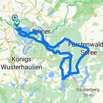
Berlin - Fürstenwalde - Berlin
A cycling route starting in Köpenick, State of Berlin, Germany.
Overview
About this route
Rode on country road instead of bike path from Fürstenwalde, not recommended during the week
- -:--
- Duration
- 92.1 km
- Distance
- 115 m
- Ascent
- 115 m
- Descent
- ---
- Avg. speed
- ---
- Max. altitude
Route quality
Waytypes & surfaces along the route
Waytypes
Path
28.6 km
(31 %)
Quiet road
19.3 km
(21 %)
Surfaces
Paved
73.7 km
(80 %)
Unpaved
3.7 km
(4 %)
Asphalt
71.9 km
(78 %)
Concrete
1.8 km
(2 %)
Continue with Bikemap
Use, edit, or download this cycling route
You would like to ride Berlin - Fürstenwalde - Berlin or customize it for your own trip? Here is what you can do with this Bikemap route:
Free features
- Save this route as favorite or in collections
- Copy & plan your own version of this route
- Split it into stages to create a multi-day tour
- Sync your route with Garmin or Wahoo
Premium features
Free trial for 3 days, or one-time payment. More about Bikemap Premium.
- Navigate this route on iOS & Android
- Export a GPX / KML file of this route
- Create your custom printout (try it for free)
- Download this route for offline navigation
Discover more Premium features.
Get Bikemap PremiumFrom our community
Other popular routes starting in Köpenick
 Rund um den Müggelsee
- Distance
- 38.2 km
- Ascent
- 620 m
- Descent
- 595 m
- Location
- Köpenick, State of Berlin, Germany
 Ost- und Randberliner Wasser-Tour
- Distance
- 62.9 km
- Ascent
- 89 m
- Descent
- 91 m
- Location
- Köpenick, State of Berlin, Germany
 Teltowkanal-Treptow-Köpenick Rundfahrt
- Distance
- 31.3 km
- Ascent
- 26 m
- Descent
- 26 m
- Location
- Köpenick, State of Berlin, Germany
 Am Müggelsee
- Distance
- 19.6 km
- Ascent
- 66 m
- Descent
- 58 m
- Location
- Köpenick, State of Berlin, Germany
 Ersatzrunde für Rund um den Scharmützelsee
- Distance
- 134.6 km
- Ascent
- 353 m
- Descent
- 349 m
- Location
- Köpenick, State of Berlin, Germany
 Carl-Spindler-Straße 13, Berlin nach Carl-Spindler-Straße 11, Berlin
- Distance
- 47.5 km
- Ascent
- 123 m
- Descent
- 128 m
- Location
- Köpenick, State of Berlin, Germany
 Rund um das Löcknitztal
- Distance
- 94.9 km
- Ascent
- 231 m
- Descent
- 229 m
- Location
- Köpenick, State of Berlin, Germany
 Vom Bahnhof Köpenick zum Bhf. Hirschgarten
- Distance
- 10 km
- Ascent
- 24 m
- Descent
- 25 m
- Location
- Köpenick, State of Berlin, Germany
Open it in the app