

Kühler Wald-Fahrrad-Weg im heißen Sommer NW - SP
A cycling route starting in Neustadt an der Weinstraße, Rhineland-Palatinate, Germany.
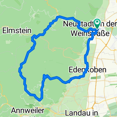
Overview
About this route
Der hier gewählte Startpunkt ist am Waldrand, kann aber genausogut am Bahnhof Neustadt-Böbig. Das ist der "Radfahrerbahnhof", man steigt gleich im Bahnhof auf das Rad und ist "Ruck-zuck" auf dem Radweg nach Speyer.
Die Strecke bietet sehr viel Wald und ist ausgezeichnet zu fahren. Ausnahme: wenn es am Vortag heftig geregnet hat. Dann ist es ratsam noch einen oder zwei Tage zuzuwarten.
Einkehr: es gibt mehrere Biergärten hinter dem Dom, siehe GPS-Route).
.
- -:--
- Duration
- 25.4 km
- Distance
- 53 m
- Ascent
- 89 m
- Descent
- ---
- Avg. speed
- ---
- Max. altitude

Route quality
Waytypes & surfaces along the route
Waytypes
Track
15.3 km
(60 %)
Quiet road
5.2 km
(20 %)
Surfaces
Paved
11.9 km
(47 %)
Unpaved
12.2 km
(48 %)
Asphalt
10.2 km
(40 %)
Gravel
8.4 km
(33 %)
Route highlights
Points of interest along the route
Point of interest after 0.5 km
Ein herrlicher Biergarten - ein wunderbarer Rastplatz. www.rothenbusch-klause.de Ein Schild am Radweg weist darauf hin, nur wenige Meter, auch mit dem Rad leicht zu fahren.
Continue with Bikemap
Use, edit, or download this cycling route
You would like to ride Kühler Wald-Fahrrad-Weg im heißen Sommer NW - SP or customize it for your own trip? Here is what you can do with this Bikemap route:
Free features
- Save this route as favorite or in collections
- Copy & plan your own version of this route
- Sync your route with Garmin or Wahoo
Premium features
Free trial for 3 days, or one-time payment. More about Bikemap Premium.
- Navigate this route on iOS & Android
- Export a GPX / KML file of this route
- Create your custom printout (try it for free)
- Download this route for offline navigation
Discover more Premium features.
Get Bikemap PremiumFrom our community
Other popular routes starting in Neustadt an der Weinstraße
 Deutschen Weinstraße Tag2
- Distance
- 52.3 km
- Ascent
- 238 m
- Descent
- 261 m
- Location
- Neustadt an der Weinstraße, Rhineland-Palatinate, Germany
 BRT2019-So Entwurf 70km
- Distance
- 62.8 km
- Ascent
- 702 m
- Descent
- 701 m
- Location
- Neustadt an der Weinstraße, Rhineland-Palatinate, Germany
 BRT2019-Fr: Durch den Gemüsegarten Deutschlands - RTF des BRT2019-Fr - 48 km Strecke
- Distance
- 48.7 km
- Ascent
- 645 m
- Descent
- 644 m
- Location
- Neustadt an der Weinstraße, Rhineland-Palatinate, Germany
 Neustadt - Kalmitrunde
- Distance
- 30.6 km
- Ascent
- 836 m
- Descent
- 839 m
- Location
- Neustadt an der Weinstraße, Rhineland-Palatinate, Germany
 BRT2019-Sa: Zur Radrennbahn und zum Rhein - 50 km Strecke
- Distance
- 50.3 km
- Ascent
- 82 m
- Descent
- 82 m
- Location
- Neustadt an der Weinstraße, Rhineland-Palatinate, Germany
 Kalmit-HohenLog Tour
- Distance
- 47.2 km
- Ascent
- 1,350 m
- Descent
- 1,350 m
- Location
- Neustadt an der Weinstraße, Rhineland-Palatinate, Germany
 Große Pfälzerwald Runde
- Distance
- 141.3 km
- Ascent
- 796 m
- Descent
- 798 m
- Location
- Neustadt an der Weinstraße, Rhineland-Palatinate, Germany
 Kalmitrunde
- Distance
- 25.9 km
- Ascent
- 808 m
- Descent
- 808 m
- Location
- Neustadt an der Weinstraße, Rhineland-Palatinate, Germany
Open it in the app