

Bury St Edmunds Hilly Loop
A cycling route starting in Bury St Edmunds, England, United Kingdom.
Overview
About this route
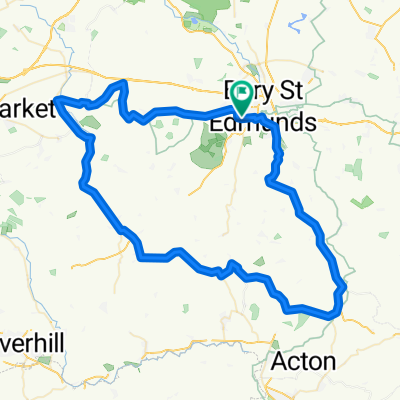
The first part of the route is one of the hilliest in Suffolk. Hartest Hill is the steepest. The route takes you down country roads through Lavenham and Bildeston before heading north through Ringshall to Stowmarket.
Go straight through the centre of Stowmarket and once out of Stowmarket follow the cycle path alongside the A14 to Haughley New Street. Although this cycle path is unpleasant and contains broken glass and some waste it would be suicidal going on the A14. Then follow the villages back into Stowmarket. There is a cycle path to the left just before you get into Bury. This cycle path is a lot nicer and gets you off the busy main road entering Bury.
If you do have problems then there are plenty of regular trains in the villages between Stowmarket and Bury.
- -:--
- Duration
- 109.2 km
- Distance
- 397 m
- Ascent
- 401 m
- Descent
- ---
- Avg. speed
- ---
- Max. altitude
Route quality
Waytypes & surfaces along the route
Waytypes
Road
47.8 km
(44 %)
Busy road
34.8 km
(32 %)
Surfaces
Paved
10.8 km
(10 %)
Unpaved
0.2 km
(<1 %)
Asphalt
9.9 km
(9 %)
Paved (undefined)
0.7 km
(<1 %)
Continue with Bikemap
Use, edit, or download this cycling route
You would like to ride Bury St Edmunds Hilly Loop or customize it for your own trip? Here is what you can do with this Bikemap route:
Free features
- Save this route as favorite or in collections
- Copy & plan your own version of this route
- Split it into stages to create a multi-day tour
- Sync your route with Garmin or Wahoo
Premium features
Free trial for 3 days, or one-time payment. More about Bikemap Premium.
- Navigate this route on iOS & Android
- Export a GPX / KML file of this route
- Create your custom printout (try it for free)
- Download this route for offline navigation
Discover more Premium features.
Get Bikemap PremiumFrom our community
Other popular routes starting in Bury St Edmunds
 BSE Kentford Hargrave BSE loop
- Distance
- 54.8 km
- Ascent
- 254 m
- Descent
- 254 m
- Location
- Bury St Edmunds, England, United Kingdom
 39k bury north
- Distance
- 39.3 km
- Ascent
- 156 m
- Descent
- 156 m
- Location
- Bury St Edmunds, England, United Kingdom
 5k for nhs
- Distance
- 50.5 km
- Ascent
- 162 m
- Descent
- 159 m
- Location
- Bury St Edmunds, England, United Kingdom
 Suffolk Cycle One
- Distance
- 48.4 km
- Ascent
- 0 m
- Descent
- 0 m
- Location
- Bury St Edmunds, England, United Kingdom
 tour de bury smol
- Distance
- 37 km
- Ascent
- 145 m
- Descent
- 144 m
- Location
- Bury St Edmunds, England, United Kingdom
 BURY-LAVENHAM-WICKHAMBROOK-MOULTON-BURY
- Distance
- 75 km
- Ascent
- 358 m
- Descent
- 358 m
- Location
- Bury St Edmunds, England, United Kingdom
 Wherstead circuit
- Distance
- 17.6 km
- Ascent
- 130 m
- Descent
- 130 m
- Location
- Bury St Edmunds, England, United Kingdom
 10km ride
- Distance
- 9.6 km
- Ascent
- 54 m
- Descent
- 49 m
- Location
- Bury St Edmunds, England, United Kingdom
Open it in the app