

Dealership to Casitas Springs
A cycling route starting in Ventura, California, United States.
Overview
About this route
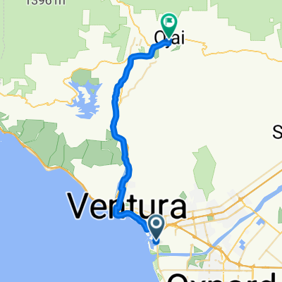
Had to have work on my car done, so i brought the bike and rode through Ventura and up to Casitas Springs (Foster Park). I tried to pick a route to avoid Highway 1 and most of Olivas, but going out had to go about a mile alongside a train track which was rather rough on a 70's roadbike. Could just avoid all that by staying on Olivas until you get to Highway 1. Track looks like I started alongside the railroad tracks but as usual I forgot to turn on my GPS. I patched it up with Google earth but the actual start was from Autocenter rd./Johnson Drive that parallels the 101 freeway.
- -:--
- Duration
- 49.5 km
- Distance
- 163 m
- Ascent
- 163 m
- Descent
- ---
- Avg. speed
- 80 m
- Max. altitude
Route quality
Waytypes & surfaces along the route
Waytypes
Cycleway
23.3 km
(47 %)
Road
10.9 km
(22 %)
Surfaces
Paved
31.2 km
(63 %)
Asphalt
27.2 km
(55 %)
Concrete
2.5 km
(5 %)
Route highlights
Points of interest along the route
Point of interest after 44.1 km
Actual start point
Continue with Bikemap
Use, edit, or download this cycling route
You would like to ride Dealership to Casitas Springs or customize it for your own trip? Here is what you can do with this Bikemap route:
Free features
- Save this route as favorite or in collections
- Copy & plan your own version of this route
- Sync your route with Garmin or Wahoo
Premium features
Free trial for 3 days, or one-time payment. More about Bikemap Premium.
- Navigate this route on iOS & Android
- Export a GPX / KML file of this route
- Create your custom printout (try it for free)
- Download this route for offline navigation
Discover more Premium features.
Get Bikemap PremiumFrom our community
Other popular routes starting in Ventura
 casitas
- Distance
- 67.5 km
- Ascent
- 589 m
- Descent
- 581 m
- Location
- Ventura, California, United States
 Ventura - Ojai OK
- Distance
- 79.5 km
- Ascent
- 566 m
- Descent
- 557 m
- Location
- Ventura, California, United States
 Ventura to Ojai
- Distance
- 31.8 km
- Ascent
- 247 m
- Descent
- 24 m
- Location
- Ventura, California, United States
 2827–2855 CA-1, Ventura to 6145 Carpinteria Ave, Carpinteria
- Distance
- 18.5 km
- Ascent
- 3 m
- Descent
- 6 m
- Location
- Ventura, California, United States
 2008 Ventura Day 1
- Distance
- 79.4 km
- Ascent
- 581 m
- Descent
- 582 m
- Location
- Ventura, California, United States
 Dealership to Casitas Springs
- Distance
- 49.5 km
- Ascent
- 163 m
- Descent
- 163 m
- Location
- Ventura, California, United States
 Ventura Cycling
- Distance
- 35 km
- Ascent
- 151 m
- Descent
- 150 m
- Location
- Ventura, California, United States
 Hakane Sushi
- Distance
- 33.2 km
- Ascent
- 246 m
- Descent
- 40 m
- Location
- Ventura, California, United States
Open it in the app