

Chili's Ride
A cycling route starting in La Mesa, California, United States.
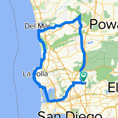
Overview
About this route
Chili's Ride Starts every Saturday 8:15 am
Mostly Adams Ave. Team ride with around 40-60 riders. One hill top finish and one sprint finish. A good ride for someone in the down town area that doesn't want to do SDBC or Swami's
The Route can be extended if you take the bicycle path out the 52 to Santee and take Mission Gorge Road back to the Chili's parking lot 51mile road trip.
- -:--
- Duration
- 60.7 km
- Distance
- 330 m
- Ascent
- 332 m
- Descent
- ---
- Avg. speed
- ---
- Max. altitude
Route quality
Waytypes & surfaces along the route
Waytypes
Road
14 km
(23 %)
Quiet road
7.9 km
(13 %)
Surfaces
Paved
31.5 km
(52 %)
Unpaved
0.6 km
(1 %)
Asphalt
30.3 km
(50 %)
Paved (undefined)
0.6 km
(1 %)
Continue with Bikemap
Use, edit, or download this cycling route
You would like to ride Chili's Ride or customize it for your own trip? Here is what you can do with this Bikemap route:
Free features
- Save this route as favorite or in collections
- Copy & plan your own version of this route
- Sync your route with Garmin or Wahoo
Premium features
Free trial for 3 days, or one-time payment. More about Bikemap Premium.
- Navigate this route on iOS & Android
- Export a GPX / KML file of this route
- Create your custom printout (try it for free)
- Download this route for offline navigation
Discover more Premium features.
Get Bikemap PremiumFrom our community
Other popular routes starting in La Mesa
 2. san diego lake Murray - Palomar Mountain
- Distance
- 147.4 km
- Ascent
- 2,528 m
- Descent
- 1,069 m
- Location
- La Mesa, California, United States
 Chargers Day Ride
- Distance
- 80.2 km
- Ascent
- 529 m
- Descent
- 479 m
- Location
- La Mesa, California, United States
 Lake Murray
- Distance
- 9.1 km
- Ascent
- 21 m
- Descent
- 19 m
- Location
- La Mesa, California, United States
 Bruce Millikin Century NOV2013 TREK
- Distance
- 161.3 km
- Ascent
- 720 m
- Descent
- 720 m
- Location
- La Mesa, California, United States
 Chili's Ride
- Distance
- 60.7 km
- Ascent
- 330 m
- Descent
- 332 m
- Location
- La Mesa, California, United States
 Tierrasanta Loop, MCAS & Qualcomm Hill
- Distance
- 60.5 km
- Ascent
- 521 m
- Descent
- 523 m
- Location
- La Mesa, California, United States
 Tierrasanta & MCAS Loop
- Distance
- 44 km
- Ascent
- 401 m
- Descent
- 401 m
- Location
- La Mesa, California, United States
 Recovered Route
- Distance
- 21.3 km
- Ascent
- 246 m
- Descent
- 242 m
- Location
- La Mesa, California, United States
Open it in the app