

passathon Touren Vorarlberg August 2021
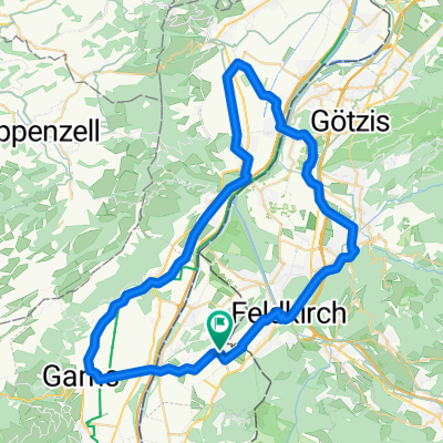
passathon Tour 11.08.2021 – Oberland Rheintal
A cycling route starting in Feldkirch, Vorarlberg, Austria.
Overview
About this route
When: Wednesday, 11.8.2021 from 2:00 PM to 6:20 PM
Where: Start: 2:00 PM Montforthaus Feldkirch, Montfortplatz 1, Feldkirch Finish: 6:20 PM Altach Train Station
Route: Feldkirch, Rankweil, Muntlix, Sulz, Röthis, Weiler, Klaus, Götzis, Altach
What: 18 passathon lighthouses of sustainable architecture
- -:--
- Duration
- 39 km
- Distance
- 157 m
- Ascent
- 176 m
- Descent
- ---
- Avg. speed
- 500 m
- Max. altitude

Part of
Route quality
Waytypes & surfaces along the route
Waytypes
Quiet road
16.4 km
(42 %)
Cycleway
4.7 km
(12 %)
Surfaces
Paved
34.7 km
(89 %)
Unpaved
3.5 km
(9 %)
Asphalt
34.7 km
(89 %)
Gravel
2.7 km
(7 %)
Continue with Bikemap
Use, edit, or download this cycling route
You would like to ride passathon Tour 11.08.2021 – Oberland Rheintal or customize it for your own trip? Here is what you can do with this Bikemap route:
Free features
- Save this route as favorite or in collections
- Copy & plan your own version of this route
- Sync your route with Garmin or Wahoo
Premium features
Free trial for 3 days, or one-time payment. More about Bikemap Premium.
- Navigate this route on iOS & Android
- Export a GPX / KML file of this route
- Create your custom printout (try it for free)
- Download this route for offline navigation
Discover more Premium features.
Get Bikemap PremiumFrom our community
Other popular routes starting in Feldkirch
 Bodensee Neusiedlersee
- Distance
- 982.6 km
- Ascent
- 307 m
- Descent
- 637 m
- Location
- Feldkirch, Vorarlberg, Austria
 Homeroute of Course
- Distance
- 9.2 km
- Ascent
- 542 m
- Descent
- 542 m
- Location
- Feldkirch, Vorarlberg, Austria
 Stella 2
- Distance
- 6.2 km
- Ascent
- 23 m
- Descent
- 845 m
- Location
- Feldkirch, Vorarlberg, Austria
 Leonhardsplatz, Feldkirch nach Rheindamm, Gemeinde Gamprin
- Distance
- 10.7 km
- Ascent
- 145 m
- Descent
- 173 m
- Location
- Feldkirch, Vorarlberg, Austria
 App. Achterbahn
- Distance
- 100.7 km
- Ascent
- 1,828 m
- Descent
- 1,489 m
- Location
- Feldkirch, Vorarlberg, Austria
 Schwägalp
- Distance
- 103.7 km
- Ascent
- 1,490 m
- Descent
- 1,452 m
- Location
- Feldkirch, Vorarlberg, Austria
 Runde Gams-Altstätten-Koblach-Feldkirch
- Distance
- 59.3 km
- Ascent
- 394 m
- Descent
- 396 m
- Location
- Feldkirch, Vorarlberg, Austria
 passathon Tour 11.08.2021 – Oberland Rheintal
- Distance
- 39 km
- Ascent
- 157 m
- Descent
- 176 m
- Location
- Feldkirch, Vorarlberg, Austria
Open it in the app