
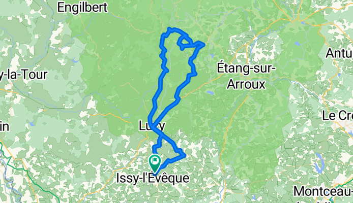
Bocycle Mont Beuvray
A cycling route starting in Luzy, Bourgogne-Franche-Comté, France.
Overview
About this route
Prachtige fietstocht in het mooie natuurgebied Du Morvan. Hoogste punt is de Mont Beuvray op 821 meter. De weg naar de top kent steile klimmen van 19%.
- -:--
- Duration
- 84.1 km
- Distance
- 1,064 m
- Ascent
- 1,064 m
- Descent
- ---
- Avg. speed
- ---
- Max. altitude

Route quality
Waytypes & surfaces along the route
Waytypes
Busy road
37.2 km
(44 %)
Quiet road
33.3 km
(40 %)
Surfaces
Paved
21.1 km
(25 %)
Unpaved
0.5 km
(<1 %)
Asphalt
21.1 km
(25 %)
Ground
0.4 km
(<1 %)
Continue with Bikemap
Use, edit, or download this cycling route
You would like to ride Bocycle Mont Beuvray or customize it for your own trip? Here is what you can do with this Bikemap route:
Free features
- Save this route as favorite or in collections
- Copy & plan your own version of this route
- Split it into stages to create a multi-day tour
- Sync your route with Garmin or Wahoo
Premium features
Free trial for 3 days, or one-time payment. More about Bikemap Premium.
- Navigate this route on iOS & Android
- Export a GPX / KML file of this route
- Create your custom printout (try it for free)
- Download this route for offline navigation
Discover more Premium features.
Get Bikemap PremiumFrom our community
Other popular routes starting in Luzy
 Patrick 001 (63 km)
- Distance
- 62.6 km
- Ascent
- 728 m
- Descent
- 905 m
- Location
- Luzy, Bourgogne-Franche-Comté, France
 Luzy - Millay (40km)
- Distance
- 40 km
- Ascent
- 434 m
- Descent
- 435 m
- Location
- Luzy, Bourgogne-Franche-Comté, France
 Luzy - Issy (37 km - 370 hm)
- Distance
- 37.1 km
- Ascent
- 414 m
- Descent
- 411 m
- Location
- Luzy, Bourgogne-Franche-Comté, France
 Millay - Larochemillay (46 km, 770 hm)
- Distance
- 45.8 km
- Ascent
- 639 m
- Descent
- 639 m
- Location
- Luzy, Bourgogne-Franche-Comté, France
 Rondje Semelay en Chides (circa 42 km, 550 hm)
- Distance
- 41.5 km
- Ascent
- 487 m
- Descent
- 487 m
- Location
- Luzy, Bourgogne-Franche-Comté, France
 Bocycle Mont Dardon
- Distance
- 32 km
- Ascent
- 495 m
- Descent
- 492 m
- Location
- Luzy, Bourgogne-Franche-Comté, France
 L2R - 05 - Luzy to Lyon
- Distance
- 170.7 km
- Ascent
- 984 m
- Descent
- 1,001 m
- Location
- Luzy, Bourgogne-Franche-Comté, France
 rondje van af de camping
- Distance
- 48 km
- Ascent
- 669 m
- Descent
- 669 m
- Location
- Luzy, Bourgogne-Franche-Comté, France
Open it in the app