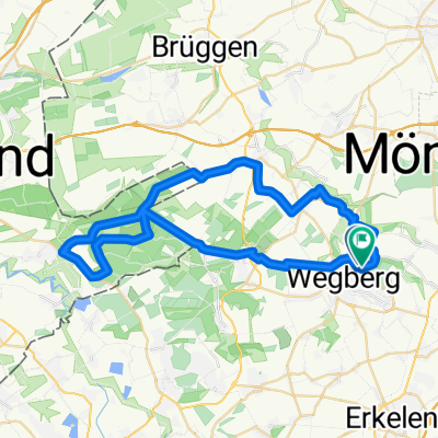
ALL-Priorshof-RYStadium
A cycling route starting in Wegberg, North Rhine-Westphalia, Germany.
Overview
About this route
Begegnungsstätte&Landschaften in MG
Rückkehrstrecke in normalen nicht allzu befahrenen Strassen
eine Radwegstrecke an sehr befahrenen Strassen ist auch angegeben
- -:--
- Duration
- 10.8 km
- Distance
- 44 m
- Ascent
- 64 m
- Descent
- ---
- Avg. speed
- ---
- Max. altitude
Route quality
Waytypes & surfaces along the route
Waytypes
Quiet road
7.2 km
(67 %)
Track
1.7 km
(16 %)
Surfaces
Paved
5.8 km
(54 %)
Unpaved
0.2 km
(2 %)
Asphalt
5.8 km
(54 %)
Ground
0.2 km
(2 %)
Undefined
4.8 km
(44 %)
Route highlights
Points of interest along the route
Point of interest after 3.7 km
Radweg
Point of interest after 6 km
Radweg
Point of interest after 6.4 km
Radweg
Point of interest after 7.3 km
Radweg
Continue with Bikemap
Use, edit, or download this cycling route
You would like to ride ALL-Priorshof-RYStadium or customize it for your own trip? Here is what you can do with this Bikemap route:
Free features
- Save this route as favorite or in collections
- Copy & plan your own version of this route
- Sync your route with Garmin or Wahoo
Premium features
Free trial for 3 days, or one-time payment. More about Bikemap Premium.
- Navigate this route on iOS & Android
- Export a GPX / KML file of this route
- Create your custom printout (try it for free)
- Download this route for offline navigation
Discover more Premium features.
Get Bikemap PremiumFrom our community
Other popular routes starting in Wegberg
27.09.2020 Wegberg, Schwanenberg, Erkelenz, Wegberg- Distance
- 32.1 km
- Ascent
- 189 m
- Descent
- 186 m
- Location
- Wegberg, North Rhine-Westphalia, Germany
NR914: Wegberger Mühlentour- Distance
- 43 km
- Ascent
- 180 m
- Descent
- 178 m
- Location
- Wegberg, North Rhine-Westphalia, Germany
RTF Rheindahlen Zweiländerfahrt 72,7km- Distance
- 72.6 km
- Ascent
- 159 m
- Descent
- 152 m
- Location
- Wegberg, North Rhine-Westphalia, Germany
Schwalm-Nette Maas Radtour- Distance
- 62.6 km
- Ascent
- 74 m
- Descent
- 116 m
- Location
- Wegberg, North Rhine-Westphalia, Germany
Moorshoven - Brachter Wald- Distance
- 68.5 km
- Ascent
- 309 m
- Descent
- 310 m
- Location
- Wegberg, North Rhine-Westphalia, Germany
1.tag- Distance
- 24 km
- Ascent
- 102 m
- Descent
- 52 m
- Location
- Wegberg, North Rhine-Westphalia, Germany
Wegberg Garzweiler Tagebau- Distance
- 21.1 km
- Ascent
- 76 m
- Descent
- 36 m
- Location
- Wegberg, North Rhine-Westphalia, Germany
50plus Route 2018- Distance
- 37.1 km
- Ascent
- 109 m
- Descent
- 109 m
- Location
- Wegberg, North Rhine-Westphalia, Germany
Open it in the app

