Dahn Rennrad
- 87.9 km
- 1,213 m
- 1,216 m
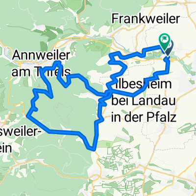
- Siebeldingen, Rhineland-Palatinate, Germany
A cycling route starting in Siebeldingen, Rhineland-Palatinate, Germany.
Overview
Siebeldingen - (Cycle Path of the German Wine Route) - Leinsweiler - Klingenmünster - (Klingenbach Cycle Path) - Rohrbach - Herxheim - Hördt - (Rhine Cycle Path D8) - Leimersheim - Wörth a. Rhein - Maximiliansau - Neuburg a.Rhein - or 5.4 km via the Rhine ferry to Rheinstetten, depending on the hotel
created this 4 years ago
Route quality
Track
45.2 km
(55 %)
Quiet road
12.3 km
(15 %)
Paved
75.6 km
(92 %)
Unpaved
3.3 km
(4 %)
Asphalt
67.4 km
(82 %)
Concrete
6.6 km
(8 %)
Route highlights
Evtl Badestelle am Rheinarm?
Badestelle am Altrhein?
reinfahren und dann links - evtl Badestelle am Altrhein Leimersheim
Badestelle am Oberer Altrhein?
Evtl Abzweigung zum Baggersee Wörth - Badestelle?
Ratjens Baggersee Wörth - Badestelle?
Badestelle?
Continue with Bikemap
You would like to ride RLP15a: Siebeldingen - Neuburg a.Rhein 82.2km 207hm or customize it for your own trip? Here is what you can do with this Bikemap route:
Free trial for 3 days, or one-time payment. More about Bikemap Premium.
Discover more Premium features.
Get Bikemap PremiumFrom our community
Open it in the app