

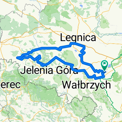
Zarków - Wierzbna - Panków - Borzygniew - Mietków - 28.04.2011
A cycling route starting in Żarów, Lower Silesian Voivodeship, Poland.
Overview
About this route
- -:--
- Duration
- 27.6 km
- Distance
- 115 m
- Ascent
- 170 m
- Descent
- ---
- Avg. speed
- ---
- Max. altitude

Route highlights
Points of interest along the route

Point of interest after 4.6 km

Point of interest after 4.6 km

Point of interest after 4.6 km

Point of interest after 6.8 km

Point of interest after 6.9 km

Point of interest after 8.5 km

Point of interest after 8.9 km

Point of interest after 8.9 km

Point of interest after 9.5 km

Point of interest after 12.9 km

Point of interest after 12.9 km

Point of interest after 12.9 km

Point of interest after 13 km

Point of interest after 16.2 km
Domanice - kościół św. Anny

Point of interest after 19.7 km
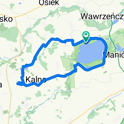
widok na Slęże

Point of interest after 22.4 km
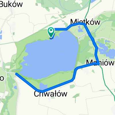
Widok na Jezioro Mietkowskie w na brzegu widoczne kościół i ruiny w Borzygniewie

Point of interest after 23.4 km

Point of interest after 24.6 km
ruiny zamku w Borzygniewie

Point of interest after 24.7 km
kościół św. Barbary w Borzygniewie
Continue with Bikemap
Use, edit, or download this cycling route
You would like to ride Zarków - Wierzbna - Panków - Borzygniew - Mietków - 28.04.2011 or customize it for your own trip? Here is what you can do with this Bikemap route:
Free features
- Save this route as favorite or in collections
- Copy & plan your own version of this route
- Sync your route with Garmin or Wahoo
Premium features
Free trial for 3 days, or one-time payment. More about Bikemap Premium.
- Navigate this route on iOS & Android
- Export a GPX / KML file of this route
- Create your custom printout (try it for free)
- Download this route for offline navigation
Discover more Premium features.
Get Bikemap PremiumFrom our community
Other popular routes starting in Żarów
 drobna przejażdżka2
- Distance
- 20.1 km
- Ascent
- 77 m
- Descent
- 94 m
- Location
- Żarów, Lower Silesian Voivodeship, Poland
 T1.mega
- Distance
- 170.8 km
- Ascent
- 996 m
- Descent
- 996 m
- Location
- Żarów, Lower Silesian Voivodeship, Poland
 Dzikowa 3, Mietków do Szczęśliwa 29, Wrocław
- Distance
- 43.5 km
- Ascent
- 475 m
- Descent
- 525 m
- Location
- Żarów, Lower Silesian Voivodeship, Poland
 Trasa z Wałbrzyska 12–29A, Borzygniew
- Distance
- 15 km
- Ascent
- 78 m
- Descent
- 81 m
- Location
- Żarów, Lower Silesian Voivodeship, Poland
 góry Kaczawskie deszcz
- Distance
- 306.1 km
- Ascent
- 1,109 m
- Descent
- 1,105 m
- Location
- Żarów, Lower Silesian Voivodeship, Poland
 Tour de Bałtyk
- Distance
- 801.7 km
- Ascent
- 412 m
- Descent
- 579 m
- Location
- Żarów, Lower Silesian Voivodeship, Poland
 Czereśniowa do Czereśniowa
- Distance
- 33.6 km
- Ascent
- 141 m
- Descent
- 140 m
- Location
- Żarów, Lower Silesian Voivodeship, Poland
 triathlon Mietków 2016
- Distance
- 45.9 km
- Ascent
- 221 m
- Descent
- 221 m
- Location
- Żarów, Lower Silesian Voivodeship, Poland
Open it in the app