

Mangfalltal Tegernsee Kreuzberg Schliersee
A cycling route starting in Weyarn, Bavaria, Germany.
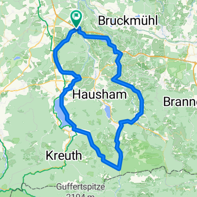
Overview
About this route
Rundtour mit Ausgangspunkt im Mühltal unterhal der Mangfallbrücke (Autobahn A8). Schöne Einkehrmöglichkeit auf der Kreuzbergalm und am Tourende im Mühltal
- -:--
- Duration
- 50.7 km
- Distance
- 648 m
- Ascent
- 648 m
- Descent
- ---
- Avg. speed
- ---
- Max. altitude
Continue with Bikemap
Use, edit, or download this cycling route
You would like to ride Mangfalltal Tegernsee Kreuzberg Schliersee or customize it for your own trip? Here is what you can do with this Bikemap route:
Free features
- Save this route as favorite or in collections
- Copy & plan your own version of this route
- Sync your route with Garmin or Wahoo
Premium features
Free trial for 3 days, or one-time payment. More about Bikemap Premium.
- Navigate this route on iOS & Android
- Export a GPX / KML file of this route
- Create your custom printout (try it for free)
- Download this route for offline navigation
Discover more Premium features.
Get Bikemap PremiumFrom our community
Other popular routes starting in Weyarn
 Thalham-Sachsenkam über Taubenberg
- Distance
- 37.6 km
- Ascent
- 393 m
- Descent
- 430 m
- Location
- Weyarn, Bavaria, Germany
 Taubenberg Seehamersee Runde
- Distance
- 33.3 km
- Ascent
- 618 m
- Descent
- 618 m
- Location
- Weyarn, Bavaria, Germany
 MTB-Taubenberg-Seehamersee-33km
- Distance
- 33.3 km
- Ascent
- 528 m
- Descent
- 528 m
- Location
- Weyarn, Bavaria, Germany
 Miesbach - Tegernsee - Spitzingsee - Miesbach
- Distance
- 84.3 km
- Ascent
- 935 m
- Descent
- 935 m
- Location
- Weyarn, Bavaria, Germany
 Mitterdarching - Valepp
- Distance
- 89.6 km
- Ascent
- 876 m
- Descent
- 879 m
- Location
- Weyarn, Bavaria, Germany
 Taubenberg Seehamersee Runde
- Distance
- 33.3 km
- Ascent
- 527 m
- Descent
- 527 m
- Location
- Weyarn, Bavaria, Germany
 Irschenberg-Tegernsee-Valepp-Elbach-Niklaskreuth
- Distance
- 109.5 km
- Ascent
- 1,027 m
- Descent
- 1,025 m
- Location
- Weyarn, Bavaria, Germany
 Mangfall 18 km
- Distance
- 17.8 km
- Ascent
- 294 m
- Descent
- 167 m
- Location
- Weyarn, Bavaria, Germany
Open it in the app