

Bear Trails - Ultimate Enduro Experience
A cycling route starting in Molveno, Trentino-Alto Adige, Italy.
Overview
About this route
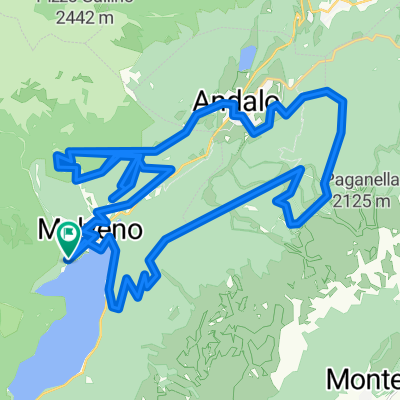
Molveno - Rif. "La Montanara" - Ex Vivaio forestale - Loc. Priori (Tana dell'Ermellino) - Andalo - Cima Paganella - Santel - Malga Brenzi - Monte Corno - Spormaggiore - Santel - Meriz - Andalo - Doss Pelà - Bait del Germano - Molveno
- -:--
- Duration
- 59.8 km
- Distance
- 4,032 m
- Ascent
- 4,038 m
- Descent
- ---
- Avg. speed
- 2,102 m
- Max. altitude

Continue with Bikemap
Use, edit, or download this cycling route
You would like to ride Bear Trails - Ultimate Enduro Experience or customize it for your own trip? Here is what you can do with this Bikemap route:
Free features
- Save this route as favorite or in collections
- Copy & plan your own version of this route
- Sync your route with Garmin or Wahoo
Premium features
Free trial for 3 days, or one-time payment. More about Bikemap Premium.
- Navigate this route on iOS & Android
- Export a GPX / KML file of this route
- Create your custom printout (try it for free)
- Download this route for offline navigation
Discover more Premium features.
Get Bikemap PremiumFrom our community
Other popular routes starting in Molveno
3121®
Molveno Cycling- Distance
- 41.5 km
- Ascent
- 1,931 m
- Descent
- 1,917 m
- Location
- Molveno, Trentino-Alto Adige, Italy
 Bear trail_Modificato
- Distance
- 46.3 km
- Ascent
- 3,030 m
- Descent
- 3,033 m
- Location
- Molveno, Trentino-Alto Adige, Italy
 Andalo
- Distance
- 44.7 km
- Ascent
- 1,440 m
- Descent
- 1,441 m
- Location
- Molveno, Trentino-Alto Adige, Italy
 Sentiero per Lago nach Strada Regionale
- Distance
- 44.3 km
- Ascent
- 885 m
- Descent
- 1,667 m
- Location
- Molveno, Trentino-Alto Adige, Italy
 Molveno - Rifugio Croz dell' Altissimo
- Distance
- 6.4 km
- Ascent
- 615 m
- Descent
- 10 m
- Location
- Molveno, Trentino-Alto Adige, Italy
 giro molveno
- Distance
- 140.4 km
- Ascent
- 2,365 m
- Descent
- 2,365 m
- Location
- Molveno, Trentino-Alto Adige, Italy
 Girolago
- Distance
- 20.3 km
- Ascent
- 359 m
- Descent
- 359 m
- Location
- Molveno, Trentino-Alto Adige, Italy
 Tour de Dolomity 2013 - Stage 2
- Distance
- 56 km
- Ascent
- 1,171 m
- Descent
- 1,020 m
- Location
- Molveno, Trentino-Alto Adige, Italy
Open it in the app