

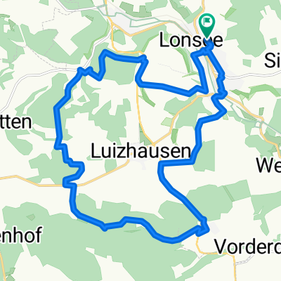
Luizhausen - Ulm Hbf
A cycling route starting in Lonsee, Baden-Wurttemberg, Germany.
Overview
About this route
Nice cycling path, without dangerous roads
- -:--
- Duration
- 21.7 km
- Distance
- 53 m
- Ascent
- 199 m
- Descent
- ---
- Avg. speed
- ---
- Max. altitude
Route quality
Waytypes & surfaces along the route
Waytypes
Track
11.9 km
(55 %)
Quiet road
2.8 km
(13 %)
Surfaces
Paved
17.2 km
(79 %)
Unpaved
3.3 km
(15 %)
Asphalt
12.6 km
(58 %)
Paved (undefined)
4.6 km
(21 %)
Continue with Bikemap
Use, edit, or download this cycling route
You would like to ride Luizhausen - Ulm Hbf or customize it for your own trip? Here is what you can do with this Bikemap route:
Free features
- Save this route as favorite or in collections
- Copy & plan your own version of this route
- Sync your route with Garmin or Wahoo
Premium features
Free trial for 3 days, or one-time payment. More about Bikemap Premium.
- Navigate this route on iOS & Android
- Export a GPX / KML file of this route
- Create your custom printout (try it for free)
- Download this route for offline navigation
Discover more Premium features.
Get Bikemap PremiumFrom our community
Other popular routes starting in Lonsee
 MERKLESHOF
- Distance
- 30.2 km
- Ascent
- 254 m
- Descent
- 254 m
- Location
- Lonsee, Baden-Wurttemberg, Germany
 Around Luiza
- Distance
- 19.9 km
- Ascent
- 360 m
- Descent
- 360 m
- Location
- Lonsee, Baden-Wurttemberg, Germany
 Hausrunde Julian
- Distance
- 13.8 km
- Ascent
- 263 m
- Descent
- 266 m
- Location
- Lonsee, Baden-Wurttemberg, Germany
 Berg und Tal unddrunter und drüber
- Distance
- 14.6 km
- Ascent
- 346 m
- Descent
- 346 m
- Location
- Lonsee, Baden-Wurttemberg, Germany
 Berg und Talbahn
- Distance
- 36 km
- Ascent
- 638 m
- Descent
- 638 m
- Location
- Lonsee, Baden-Wurttemberg, Germany
 Temmenhausen - Scharenstetten - Radelstetten
- Distance
- 16.7 km
- Ascent
- 213 m
- Descent
- 212 m
- Location
- Lonsee, Baden-Wurttemberg, Germany
 30km
30km- Distance
- 29.6 km
- Ascent
- 232 m
- Descent
- 232 m
- Location
- Lonsee, Baden-Wurttemberg, Germany
 Lonsee – Splügen - San-Bernardino - Comer-See - Lonsee Tag 1
- Distance
- 157.1 km
- Ascent
- 398 m
- Descent
- 533 m
- Location
- Lonsee, Baden-Wurttemberg, Germany
Open it in the app