
NDH-SHA
A cycling route starting in Niedernhall, Baden-Württemberg, Germany.
Overview
About this route
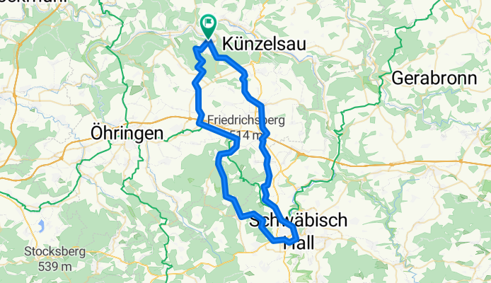
Von der Giebelheide in Niedernhall nach Schwäbisch Hall, zurück über das Gnadentahl / Waldenburg auf die Giebelheide.
- -:--
- Duration
- 62.9 km
- Distance
- 603 m
- Ascent
- 592 m
- Descent
- ---
- Avg. speed
- 504 m
- Max. altitude

Route quality
Waytypes & surfaces along the route
Waytypes
Quiet road
24.1 km
(38 %)
Track
15.3 km
(24 %)
Surfaces
Paved
52.9 km
(84 %)
Unpaved
4 km
(6 %)
Asphalt
48.4 km
(77 %)
Paved (undefined)
4.6 km
(7 %)
Continue with Bikemap
Use, edit, or download this cycling route
You would like to ride NDH-SHA or customize it for your own trip? Here is what you can do with this Bikemap route:
Free features
- Save this route as favorite or in collections
- Copy & plan your own version of this route
- Sync your route with Garmin or Wahoo
Premium features
Free trial for 3 days, or one-time payment. More about Bikemap Premium.
- Navigate this route on iOS & Android
- Export a GPX / KML file of this route
- Create your custom printout (try it for free)
- Download this route for offline navigation
Discover more Premium features.
Get Bikemap PremiumFrom our community
Other popular routes starting in Niedernhall
 Trainingsstrecke
- Distance
- 31.5 km
- Ascent
- 388 m
- Descent
- 474 m
- Location
- Niedernhall, Baden-Württemberg, Germany
 April-Runde
- Distance
- 122.3 km
- Ascent
- 1,001 m
- Descent
- 1,001 m
- Location
- Niedernhall, Baden-Württemberg, Germany
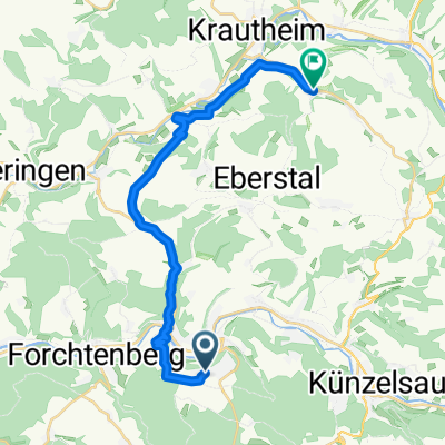 Abt-Knittel-Straße 92, Niedernhall nach Hohbergstraße 2, Krautheim
- Distance
- 19.3 km
- Ascent
- 311 m
- Descent
- 408 m
- Location
- Niedernhall, Baden-Württemberg, Germany
 N´hall-Waldenburg-Öhringen-N´hall
- Distance
- 51.9 km
- Ascent
- 578 m
- Descent
- 653 m
- Location
- Niedernhall, Baden-Württemberg, Germany
 WE Radchallenge
- Distance
- 281.4 km
- Ascent
- 1,058 m
- Descent
- 1,131 m
- Location
- Niedernhall, Baden-Württemberg, Germany
 Neu-Öhr-Ohr-For-Neu
- Distance
- 42.5 km
- Ascent
- 262 m
- Descent
- 262 m
- Location
- Niedernhall, Baden-Württemberg, Germany
 Kocher-Hohe-Strasse-1
- Distance
- 52.4 km
- Ascent
- 578 m
- Descent
- 583 m
- Location
- Niedernhall, Baden-Württemberg, Germany
 Abt-Knittel-Straße 89, Niedernhall nach Abt-Knittel-Straße 89, Niedernhall
- Distance
- 14 km
- Ascent
- 196 m
- Descent
- 196 m
- Location
- Niedernhall, Baden-Württemberg, Germany
Open it in the app