Via Francigena in Bici - Tappa B11 - Da Berceto a Aulla
A cycling route starting in Berceto, Emilia-Romagna, Italy.
Overview
About this route
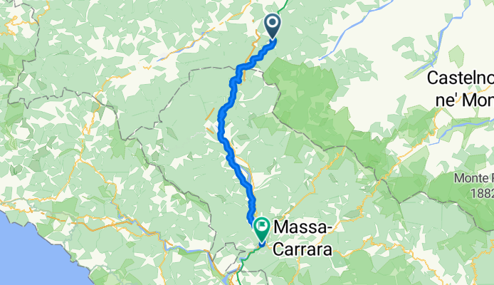
START: Berceto, San Moderanno
FINISH: Aulla, Abbey of St. Caprasio
LENGTH: 51.4 km
BIKE TYPE: Hybrid
CYCLING DIFFICULTY: Very challenging
- -:--
- Duration
- 51.4 km
- Distance
- 324 m
- Ascent
- 1,076 m
- Descent
- ---
- Avg. speed
- 1,026 m
- Max. altitude
Route quality
Waytypes & surfaces along the route
Waytypes
Quiet road
8.2 km
(16 %)
Road
5.1 km
(10 %)
Surfaces
Paved
21.1 km
(41 %)
Unpaved
0.5 km
(1 %)
Asphalt
19.5 km
(38 %)
Concrete
1.5 km
(3 %)
Continue with Bikemap
Use, edit, or download this cycling route
You would like to ride Via Francigena in Bici - Tappa B11 - Da Berceto a Aulla or customize it for your own trip? Here is what you can do with this Bikemap route:
Free features
- Save this route as favorite or in collections
- Copy & plan your own version of this route
- Sync your route with Garmin or Wahoo
Premium features
Free trial for 3 days, or one-time payment. More about Bikemap Premium.
- Navigate this route on iOS & Android
- Export a GPX / KML file of this route
- Create your custom printout (try it for free)
- Download this route for offline navigation
Discover more Premium features.
Get Bikemap PremiumFrom our community
Other popular routes starting in Berceto
- Giro D'Italia stage 4. Berceto to La Spezia
- Distance
- 73.4 km
- Ascent
- 967 m
- Descent
- 1,763 m
- Location
- Berceto, Emilia-Romagna, Italy
- Via Francigena 2ème partie (Passo della Cisa - Roma)
- Distance
- 529.5 km
- Ascent
- 2,559 m
- Descent
- 3,428 m
- Location
- Berceto, Emilia-Romagna, Italy
- Berceto Pontremoli
- Distance
- 29.1 km
- Ascent
- 332 m
- Descent
- 897 m
- Location
- Berceto, Emilia-Romagna, Italy
- Berceto
- Distance
- 16.9 km
- Ascent
- 651 m
- Descent
- 650 m
- Location
- Berceto, Emilia-Romagna, Italy
- Berceto - San Macario in Piano (Lucca)
- Distance
- 161.3 km
- Ascent
- 1,053 m
- Descent
- 1,918 m
- Location
- Berceto, Emilia-Romagna, Italy
- Via Francigena in Bici - Tappa B11 - Da Berceto a Aulla
- Distance
- 51.4 km
- Ascent
- 324 m
- Descent
- 1,076 m
- Location
- Berceto, Emilia-Romagna, Italy
- Passo della Cisa - Cassio - Parma
- Distance
- 61.8 km
- Ascent
- 308 m
- Descent
- 1,284 m
- Location
- Berceto, Emilia-Romagna, Italy
- Berceto-Rifugio Lagdei-Bosco-Passo Sillara-Berceto
- Distance
- 39.5 km
- Ascent
- 1,220 m
- Descent
- 1,201 m
- Location
- Berceto, Emilia-Romagna, Italy
Open it in the app