

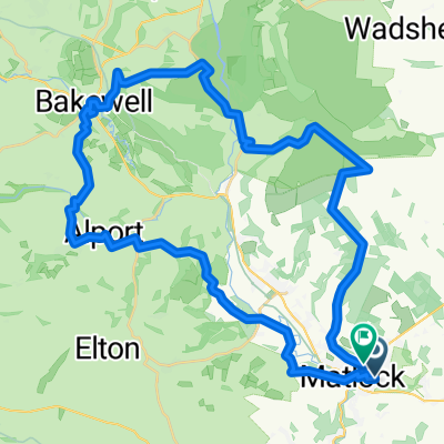
Midlands Hills #2
A cycling route starting in Matlock, England, United Kingdom.
Overview
About this route
A hard, hilly route. It's based largely on another bikemap.net route that I found; though starting out from Matlock results in departing through Bank Road, a personal favourite climb.
- -:--
- Duration
- 188 km
- Distance
- 2,164 m
- Ascent
- 2,164 m
- Descent
- ---
- Avg. speed
- ---
- Max. altitude
Route quality
Waytypes & surfaces along the route
Waytypes
Quiet road
67.7 km
(36 %)
Road
39.5 km
(21 %)
Surfaces
Paved
73.3 km
(39 %)
Unpaved
7.5 km
(4 %)
Asphalt
73.3 km
(39 %)
Gravel
7.5 km
(4 %)
Undefined
107.2 km
(57 %)
Continue with Bikemap
Use, edit, or download this cycling route
You would like to ride Midlands Hills #2 or customize it for your own trip? Here is what you can do with this Bikemap route:
Free features
- Save this route as favorite or in collections
- Copy & plan your own version of this route
- Split it into stages to create a multi-day tour
- Sync your route with Garmin or Wahoo
Premium features
Free trial for 3 days, or one-time payment. More about Bikemap Premium.
- Navigate this route on iOS & Android
- Export a GPX / KML file of this route
- Create your custom printout (try it for free)
- Download this route for offline navigation
Discover more Premium features.
Get Bikemap PremiumFrom our community
Other popular routes starting in Matlock
 New Way of the Rings Matlock to Derby
- Distance
- 42.2 km
- Ascent
- 447 m
- Descent
- 554 m
- Location
- Matlock, England, United Kingdom
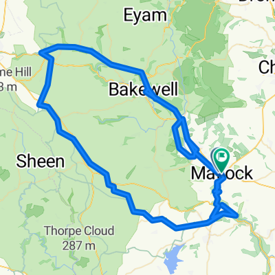
 Midlands Hills
- Distance
- 113.2 km
- Ascent
- 1,324 m
- Descent
- 1,324 m
- Location
- Matlock, England, United Kingdom
 Tansley, Riber, Snitterton
- Distance
- 20.1 km
- Ascent
- 260 m
- Descent
- 260 m
- Location
- Matlock, England, United Kingdom
 Midlands Hills #2
- Distance
- 188 km
- Ascent
- 2,164 m
- Descent
- 2,164 m
- Location
- Matlock, England, United Kingdom
 Hurst Rise 55C to Springfield Rise
- Distance
- 41.8 km
- Ascent
- 941 m
- Descent
- 920 m
- Location
- Matlock, England, United Kingdom
 Derwent Way to Derwent Way
- Distance
- 89.9 km
- Ascent
- 1,602 m
- Descent
- 1,604 m
- Location
- Matlock, England, United Kingdom
 Birchover to Stanton
- Distance
- 15.7 km
- Ascent
- 271 m
- Descent
- 271 m
- Location
- Matlock, England, United Kingdom
 hills
hills- Distance
- 135.4 km
- Ascent
- 1,992 m
- Descent
- 1,992 m
- Location
- Matlock, England, United Kingdom
Open it in the app