- 95.2 km
- 571 m
- 562 m
- Varnsdorf, Ústecký kraj, Czechia
Na Kottmar a podél Spreevy do Budyšína
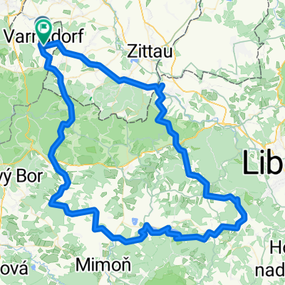
A cycling route starting in Varnsdorf, Ústecký kraj, Czechia.
Overview
About this route
The route leads from Varnsdorf to the Kottmar lookout tower and the springs of the Spree (a few meters below). It then continues along the bike path through Sohland, Schirgiswalde, to the Mönchswalderberg lookout tower, into the historic center of Bautzen, and to the Talsperre Bautzen reservoir. Finally, it returns along the bike path to Sohland via Rožany and Königreich, then along the bike path to Rumburk, Seifhennersdorf, and ends in Varnsdorf.
- -:--
- Duration
- 130.8 km
- Distance
- 732 m
- Ascent
- 733 m
- Descent
- ---
- Avg. speed
- ---
- Max. altitude
created this 14 years ago
Route quality
Waytypes & surfaces along the route
Waytypes
Quiet road
41.9 km
(32 %)
Path
17 km
(13 %)
Surfaces
Paved
78.5 km
(60 %)
Unpaved
17 km
(13 %)
Asphalt
69.3 km
(53 %)
Paved (undefined)
6.5 km
(5 %)
Route highlights
Points of interest along the route
Point of interest after 29.4 km
Spreepark
Point of interest after 50.7 km
rozhledna Mönchswalderberg
Point of interest after 104.5 km
hvězdárna
Point of interest after 107.6 km
restaurace Starý mlýn
Continue with Bikemap
Use, edit, or download this cycling route
You would like to ride Na Kottmar a podél Spreevy do Budyšína or customize it for your own trip? Here is what you can do with this Bikemap route:
Free features
- Save this route as favorite or in collections
- Copy & plan your own version of this route
- Split it into stages to create a multi-day tour
- Sync your route with Garmin or Wahoo
Premium features
Free trial for 3 days, or one-time payment. More about Bikemap Premium.
- Navigate this route on iOS & Android
- Export a GPX / KML file of this route
- Create your custom printout (try it for free)
- Download this route for offline navigation
Discover more Premium features.
Get Bikemap PremiumFrom our community
Other popular routes starting in Varnsdorf
- Na rozhledny v Německu IV.
- 20170326_140233.gpx
- 31 km
- 260 m
- 260 m
- Varnsdorf, Ústecký kraj, Czechia
- Na Obere Schleuse II
- 66.2 km
- 573 m
- 573 m
- Varnsdorf, Ústecký kraj, Czechia
- Na Děvín
- 108.2 km
- 1,049 m
- 1,043 m
- Varnsdorf, Ústecký kraj, Czechia
- Na rozhledny v Německu II.
- 80.8 km
- 823 m
- 817 m
- Varnsdorf, Ústecký kraj, Czechia
- Na Kottmar a podél Spreevy do Budyšína
- 130.8 km
- 732 m
- 733 m
- Varnsdorf, Ústecký kraj, Czechia
- Tanečnice přes prameny Mandavy a osadu Kopec
- 60.8 km
- 579 m
- 579 m
- Varnsdorf, Ústecký kraj, Czechia
- Na Studenec
- 60.5 km
- 891 m
- 894 m
- Varnsdorf, Ústecký kraj, Czechia
Open it in the app


