Narodowych Sił Zbrojnych 10, Płock do Stanisława Siennickiego 1, Płock
A cycling route starting in Płock, Masovian Voivodeship, Poland.
Overview
About this route
- 1 h 10 min
- Duration
- 17.5 km
- Distance
- 24 m
- Ascent
- 15 m
- Descent
- 15 km/h
- Avg. speed
- ---
- Avg. speed
Route quality
Waytypes & surfaces along the route
Waytypes
Cycleway
11 km
(63 %)
Quiet road
2.6 km
(15 %)
Surfaces
Paved
8.2 km
(47 %)
Asphalt
6.7 km
(39 %)
Paving stones
1.3 km
(8 %)
Continue with Bikemap
Use, edit, or download this cycling route
You would like to ride Narodowych Sił Zbrojnych 10, Płock do Stanisława Siennickiego 1, Płock or customize it for your own trip? Here is what you can do with this Bikemap route:
Free features
- Save this route as favorite or in collections
- Copy & plan your own version of this route
- Sync your route with Garmin or Wahoo
Premium features
Free trial for 3 days, or one-time payment. More about Bikemap Premium.
- Navigate this route on iOS & Android
- Export a GPX / KML file of this route
- Create your custom printout (try it for free)
- Download this route for offline navigation
Discover more Premium features.
Get Bikemap PremiumFrom our community
Other popular routes starting in Płock
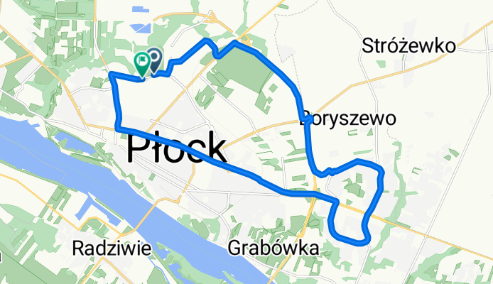
- bike tour from 16/04/16 14:55
- Distance
- 22.7 km
- Ascent
- 90 m
- Descent
- 89 m
- Location
- Płock, Masovian Voivodeship, Poland
- Słupno-Białobrzegi-Kępa Polska
- Distance
- 52.9 km
- Ascent
- 128 m
- Descent
- 144 m
- Location
- Płock, Masovian Voivodeship, Poland
- Lucień - 2011/34
- Distance
- 45.9 km
- Ascent
- 157 m
- Descent
- 156 m
- Location
- Płock, Masovian Voivodeship, Poland
- Narodowych Sił Zbrojnych 15, Płock do Stanisława Siennickiego 1, Płock
- Distance
- 50.1 km
- Ascent
- 63 m
- Descent
- 70 m
- Location
- Płock, Masovian Voivodeship, Poland
- Grabina - Łąck - Zaździerz
- Distance
- 46.2 km
- Ascent
- 139 m
- Descent
- 138 m
- Location
- Płock, Masovian Voivodeship, Poland
- VM + WTR krokta
- Distance
- 103.1 km
- Ascent
- 174 m
- Descent
- 172 m
- Location
- Płock, Masovian Voivodeship, Poland
- Rajmunda Rembielińskiego 10, Płock do Piasta Kołodzieja 2, Płock
- Distance
- 24 km
- Ascent
- 123 m
- Descent
- 156 m
- Location
- Płock, Masovian Voivodeship, Poland
- Szosą z Płocka do Warszawy
- Distance
- 97.9 km
- Ascent
- 94 m
- Descent
- 45 m
- Location
- Płock, Masovian Voivodeship, Poland
Open it in the app