

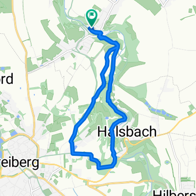
Der "Rote Graben"
A cycling route starting in Halsbrücke, Saxony, Germany.
Overview
About this route
Ideal family route along the mining-historical 'Roter Graben' between Halsbrücke and Halsbach. The open ditch carries water year-round draining from the old Freiberg mining operations. In the past, it was needed in the Halsbrücke mining district, and now you can get an impression of the scale of mining activity. The route runs mostly under trees, providing lovely shade in summer.
Perfect for families and suitable for trailers! The path is always flat, as you follow the natural gradient of the Freiberger Mulde, just a few meters above its level.
For the return trip, I recommend the right bank of the Mulde in Halsbach, and from the Fuchsmühle near Conradsdorf, heading back along the 'Roter Graben'.
- -:--
- Duration
- 6.7 km
- Distance
- 124 m
- Ascent
- 109 m
- Descent
- ---
- Avg. speed
- ---
- Max. altitude

Route quality
Waytypes & surfaces along the route
Waytypes
Access road
3.2 km
(48 %)
Track
2.9 km
(43 %)
Surfaces
Paved
1.1 km
(16 %)
Unpaved
3.6 km
(54 %)
Loose gravel
2.1 km
(31 %)
Asphalt
1.1 km
(16 %)
Continue with Bikemap
Use, edit, or download this cycling route
You would like to ride Der "Rote Graben" or customize it for your own trip? Here is what you can do with this Bikemap route:
Free features
- Save this route as favorite or in collections
- Copy & plan your own version of this route
- Sync your route with Garmin or Wahoo
Premium features
Free trial for 3 days, or one-time payment. More about Bikemap Premium.
- Navigate this route on iOS & Android
- Export a GPX / KML file of this route
- Create your custom printout (try it for free)
- Download this route for offline navigation
Discover more Premium features.
Get Bikemap PremiumFrom our community
Other popular routes starting in Halsbrücke
 Halsbrücke-Zug: Rund um Freiberg
- Distance
- 28.1 km
- Ascent
- 235 m
- Descent
- 235 m
- Location
- Halsbrücke, Saxony, Germany
 Der "Rote Graben"
- Distance
- 6.7 km
- Ascent
- 124 m
- Descent
- 109 m
- Location
- Halsbrücke, Saxony, Germany
 Muldenweg 14, Halsbrücke nach Muldenweg 8, Halsbrücke
- Distance
- 3.2 km
- Ascent
- 52 m
- Descent
- 110 m
- Location
- Halsbrücke, Saxony, Germany
 HAB-Nossen-HAB
- Distance
- 34.9 km
- Ascent
- 310 m
- Descent
- 311 m
- Location
- Halsbrücke, Saxony, Germany
 Winterrunde bei -10°C
- Distance
- 8.3 km
- Ascent
- 109 m
- Descent
- 109 m
- Location
- Halsbrücke, Saxony, Germany
 Muldenweg 8, Halsbrücke nach Muldenweg 8, Halsbrücke
- Distance
- 4.6 km
- Ascent
- 128 m
- Descent
- 116 m
- Location
- Halsbrücke, Saxony, Germany
 Halsbrücke-Halsbach-Freiberg-Halsbrücke
- Distance
- 14.9 km
- Ascent
- 182 m
- Descent
- 182 m
- Location
- Halsbrücke, Saxony, Germany
 Muldenweg 8, Halsbrücke nach Muldenweg 8, Halsbrücke
- Distance
- 8.8 km
- Ascent
- 287 m
- Descent
- 276 m
- Location
- Halsbrücke, Saxony, Germany
Open it in the app