Kós K25_2021
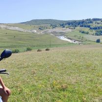
A cycling route starting in Aghireșu, Cluj County, Romania.
Overview
About this route
<p><strong>Route outline:</strong> Gyerővásárhely, Reformed Parish (START) – Jegenyei Road (Leghia) (5th CP) – Ordományos Hill – Riszeg Summit (6th CP) – Zsobok, reformed church (7th CP) – Sztána, reformed church (8th CP) – Sztána, Szentimrei villa (FINISH).</p>
Translated, show original (Polish)- -:--
- Duration
- 24.3 km
- Distance
- 541 m
- Ascent
- 647 m
- Descent
- ---
- Avg. speed
- 736 m
- Max. altitude
Route quality
Waytypes & surfaces along the route
Waytypes
Track
15.3 km
(63 %)
Road
4.4 km
(18 %)
Surfaces
Paved
6.1 km
(25 %)
Unpaved
4.9 km
(20 %)
Asphalt
6.1 km
(25 %)
Ground
3.9 km
(16 %)
Continue with Bikemap
Use, edit, or download this cycling route
You would like to ride Kós K25_2021 or customize it for your own trip? Here is what you can do with this Bikemap route:
Free features
- Save this route as favorite or in collections
- Copy & plan your own version of this route
- Sync your route with Garmin or Wahoo
Premium features
Free trial for 3 days, or one-time payment. More about Bikemap Premium.
- Navigate this route on iOS & Android
- Export a GPX / KML file of this route
- Create your custom printout (try it for free)
- Download this route for offline navigation
Discover more Premium features.
Get Bikemap PremiumFrom our community
Other popular routes starting in Aghireșu
- Dealurile Capusului
- Distance
- 45.2 km
- Ascent
- 542 m
- Descent
- 660 m
- Location
- Aghireșu, Cluj County, Romania
- DJ108C 211, Leghia - DJ108C 207, Leghia
- Distance
- 62.3 km
- Ascent
- 1,528 m
- Descent
- 1,533 m
- Location
- Aghireșu, Cluj County, Romania
- Aghiresu - Bedechiu - valea Capusului - Cluj
- Distance
- 61.4 km
- Ascent
- 415 m
- Descent
- 528 m
- Location
- Aghireșu, Cluj County, Romania
- Tura Tara Calatei - offroad
- Distance
- 28.8 km
- Ascent
- 677 m
- Descent
- 603 m
- Location
- Aghireșu, Cluj County, Romania
- Kós K16_2021
- Distance
- 16.1 km
- Ascent
- 394 m
- Descent
- 502 m
- Location
- Aghireșu, Cluj County, Romania
- Nyugodt útvonal
- Distance
- 16.3 km
- Ascent
- 359 m
- Descent
- 515 m
- Location
- Aghireșu, Cluj County, Romania
- DJ108C 3 - DJ108C 3
- Distance
- 12 km
- Ascent
- 241 m
- Descent
- 271 m
- Location
- Aghireșu, Cluj County, Romania
- Tura Tara Calatei - onroad-ish
- Distance
- 35.4 km
- Ascent
- 714 m
- Descent
- 641 m
- Location
- Aghireșu, Cluj County, Romania
Open it in the app