

CAMP - HR ALPS 2021
Day 1 - Welcome Ride - Annecy Loop Easy ride
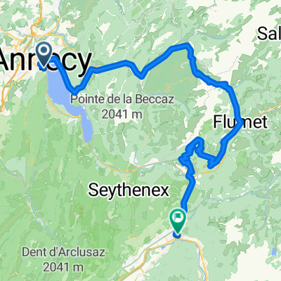
A cycling route starting in Annecy, Auvergne-Rhône-Alpes, France.
Overview
About this route
- -:--
- Duration
- 39.6 km
- Distance
- 182 m
- Ascent
- 182 m
- Descent
- ---
- Avg. speed
- 555 m
- Max. altitude

Part of
CAMP - HR ALPS 2021
7 stages
Route quality
Waytypes & surfaces along the route
Waytypes
Cycleway
25.9 km
(66 %)
Busy road
9.1 km
(23 %)
Surfaces
Paved
38 km
(96 %)
Unpaved
0.1 km
(<1 %)
Asphalt
37.2 km
(94 %)
Concrete
0.6 km
(1 %)
Route highlights
Points of interest along the route
Point of interest after 22 km
Col de la Forclaz
Continue with Bikemap
Use, edit, or download this cycling route
You would like to ride Day 1 - Welcome Ride - Annecy Loop Easy ride or customize it for your own trip? Here is what you can do with this Bikemap route:
Free features
- Save this route as favorite or in collections
- Copy & plan your own version of this route
- Sync your route with Garmin or Wahoo
Premium features
Free trial for 3 days, or one-time payment. More about Bikemap Premium.
- Navigate this route on iOS & Android
- Export a GPX / KML file of this route
- Create your custom printout (try it for free)
- Download this route for offline navigation
Discover more Premium features.
Get Bikemap PremiumFrom our community
Other popular routes starting in Annecy
 02 Annecy-Moûtiers
- Distance
- 70.8 km
- Ascent
- 294 m
- Descent
- 268 m
- Location
- Annecy, Auvergne-Rhône-Alpes, France
 Rhone-Alpes: Etappe 1
- Distance
- 100.2 km
- Ascent
- 1,888 m
- Descent
- 1,997 m
- Location
- Annecy, Auvergne-Rhône-Alpes, France
 Day 1 - Annecy to Montgilbert
- Distance
- 60.9 km
- Ascent
- 767 m
- Descent
- 678 m
- Location
- Annecy, Auvergne-Rhône-Alpes, France
 Annecy Loop 130km / 2800hm
- Distance
- 129.8 km
- Ascent
- 2,456 m
- Descent
- 2,455 m
- Location
- Annecy, Auvergne-Rhône-Alpes, France
 J3 – Arpettaz - Aravis
- Distance
- 124.9 km
- Ascent
- 3,042 m
- Descent
- 3,041 m
- Location
- Annecy, Auvergne-Rhône-Alpes, France
 2023_Frankring_Lac d'Annecy Cycle Path
- Distance
- 38.2 km
- Ascent
- 321 m
- Descent
- 321 m
- Location
- Annecy, Auvergne-Rhône-Alpes, France
 Col de la Madeleine
- Distance
- 121.5 km
- Ascent
- 1,903 m
- Descent
- 1,818 m
- Location
- Annecy, Auvergne-Rhône-Alpes, France
 Lake Annecy via Col de la Forclaz
- Distance
- 51.9 km
- Ascent
- 778 m
- Descent
- 779 m
- Location
- Annecy, Auvergne-Rhône-Alpes, France
Open it in the app