

Fügenberg-Runde im vorderen Zillertal
A cycling route starting in Strass im Zillertal, Tyrol, Austria.
Overview
About this route
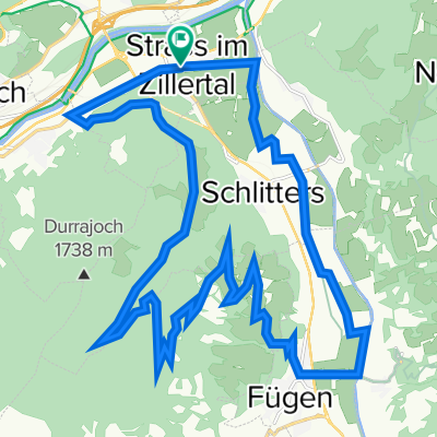
Die Runde entspricht der Tour Nr. 67 im "Tiroler Mountainbike Handbuch" von Kurt Pokos u. Christine Mühlöcker. Man beginnt die Tour im Zentrum von Strass. Vor dem Gemeindeamt gibt es einen kleinen Parkplatz. Dort läßt man das Auto stehn. Von dort fährt man auf der Dorfstraße in östliche Richtung bis zum Beginn des Zillertal-Radweges, der nach rechts in südliche Richtung führt. Weiter geht es vorbei am Badeteich Schlitters im Zick-Zack-Kurs bis auf Höhe von Fügen. Dort verlässt man den Radweg nach rechts und fährt direkt nach Fügen hinein bis zur Auffahrt nach Fügenberg. Achtung: aufgrund der neuen Bundesstraßenunterführungen und diverser neuer Kreisverkehre stimmt die Naviführung hier nicht mehr hundertprozentig! Mit Gefühl findet man jedoch trotzdem weiter! Vom Dorfinneren von Fügen geht es auf einer ständig steilen Bergstraße (Fügenberg Straße) hinauf bis zum Gasthaus Baumannwiesköpfl. Der Asphaltweg endet dann plötzlich und auf einem gut befahrbaren Wirtschaftsweg geht es noch weiter hinauf. Bei der Abzweigung zur Geolsalm bzw. Kaunzalm hat man nach 17 km den höchsten Punkt ( 1399m ) erreicht. Man fährt scharf rechts gemütlich in Richtung Martelerhof, ständig abwärts! Noch hoch über Rotholz könnte man nach rechts abbiegen zur Wallfahrtskirche Maria Brettfall und dem dortigen Gasthaus. Fährt man jedoch normal weiter und nicht nach Maria Brettfall, dann gelangt man nach Rotholz und fährt auf der Landstraße zurück in Richtung Osten nach Strass, zum Ausgangspunkt.
- -:--
- Duration
- 29.2 km
- Distance
- 944 m
- Ascent
- 944 m
- Descent
- ---
- Avg. speed
- 1,400 m
- Max. altitude

Route quality
Waytypes & surfaces along the route
Waytypes
Track
15.2 km
(52 %)
Quiet road
10.6 km
(36 %)
Surfaces
Paved
10.8 km
(37 %)
Unpaved
8.5 km
(29 %)
Asphalt
10.5 km
(36 %)
Gravel
7.5 km
(26 %)
Continue with Bikemap
Use, edit, or download this cycling route
You would like to ride Fügenberg-Runde im vorderen Zillertal or customize it for your own trip? Here is what you can do with this Bikemap route:
Free features
- Save this route as favorite or in collections
- Copy & plan your own version of this route
- Sync your route with Garmin or Wahoo
Premium features
Free trial for 3 days, or one-time payment. More about Bikemap Premium.
- Navigate this route on iOS & Android
- Export a GPX / KML file of this route
- Create your custom printout (try it for free)
- Download this route for offline navigation
Discover more Premium features.
Get Bikemap PremiumFrom our community
Other popular routes starting in Strass im Zillertal
 Zillertal 'till the end!
- Distance
- 113 km
- Ascent
- 1,296 m
- Descent
- 1,297 m
- Location
- Strass im Zillertal, Tyrol, Austria
 Trans-Alp 1. Etappe
- Distance
- 80.1 km
- Ascent
- 2,655 m
- Descent
- 1,800 m
- Location
- Strass im Zillertal, Tyrol, Austria
 10.06.24 Strass-Reischenhart Innweg 5. Etappe
- Distance
- 73.4 km
- Ascent
- 69 m
- Descent
- 137 m
- Location
- Strass im Zillertal, Tyrol, Austria
 Zillertal Anfang
- Distance
- 14.4 km
- Ascent
- 39 m
- Descent
- 16 m
- Location
- Strass im Zillertal, Tyrol, Austria
 5_Strass-Mayrhofen
- Distance
- 33 km
- Ascent
- 151 m
- Descent
- 43 m
- Location
- Strass im Zillertal, Tyrol, Austria
 Zillertal-Kitzbuhel
- Distance
- 174.9 km
- Ascent
- 1,623 m
- Descent
- 1,621 m
- Location
- Strass im Zillertal, Tyrol, Austria
 Fügenberg-Runde im vorderen Zillertal
- Distance
- 29.2 km
- Ascent
- 944 m
- Descent
- 944 m
- Location
- Strass im Zillertal, Tyrol, Austria
 Strass im Zillertal - Sterzing
- Distance
- 87.6 km
- Ascent
- 1,725 m
- Descent
- 1,305 m
- Location
- Strass im Zillertal, Tyrol, Austria
Open it in the app