

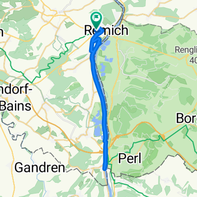
20110430-115km
A cycling route starting in Palzem, Rhineland-Palatinate, Germany.
Overview
About this route
Strecke für Ausauer zu trainieren.
Zeit : 04:14 Stunden
Schnitt : 27,5 kmh
Höhenmeter : 1098m
- -:--
- Duration
- 115.3 km
- Distance
- 566 m
- Ascent
- 566 m
- Descent
- ---
- Avg. speed
- ---
- Max. altitude
Route quality
Waytypes & surfaces along the route
Waytypes
Quiet road
13.8 km
(12 %)
Cycleway
3.5 km
(3 %)
Surfaces
Paved
110.7 km
(96 %)
Unpaved
1.2 km
(1 %)
Asphalt
109.5 km
(95 %)
Paved (undefined)
1.2 km
(1 %)
Continue with Bikemap
Use, edit, or download this cycling route
You would like to ride 20110430-115km or customize it for your own trip? Here is what you can do with this Bikemap route:
Free features
- Save this route as favorite or in collections
- Copy & plan your own version of this route
- Split it into stages to create a multi-day tour
- Sync your route with Garmin or Wahoo
Premium features
Free trial for 3 days, or one-time payment. More about Bikemap Premium.
- Navigate this route on iOS & Android
- Export a GPX / KML file of this route
- Create your custom printout (try it for free)
- Download this route for offline navigation
Discover more Premium features.
Get Bikemap PremiumFrom our community
Other popular routes starting in Palzem
 2018-J02-Remich-Sarreguemines
- Distance
- 97.9 km
- Ascent
- 367 m
- Descent
- 279 m
- Location
- Palzem, Rhineland-Palatinate, Germany
 15.07.25 Palzem - Saarlouis
- Distance
- 68 km
- Ascent
- 396 m
- Descent
- 388 m
- Location
- Palzem, Rhineland-Palatinate, Germany
 RT 48km Perl - Remich- Wormeldance-Grevemacher- Nittel- Perl
- Distance
- 47.8 km
- Ascent
- 636 m
- Descent
- 636 m
- Location
- Palzem, Rhineland-Palatinate, Germany
 20110430-115km
- Distance
- 115.3 km
- Ascent
- 566 m
- Descent
- 566 m
- Location
- Palzem, Rhineland-Palatinate, Germany
 De ¿OÑÚ? a ¿OÑÚ?
- Distance
- 20 km
- Ascent
- 74 m
- Descent
- 51 m
- Location
- Palzem, Rhineland-Palatinate, Germany
 3-Länder-Tour
- Distance
- 107.1 km
- Ascent
- 737 m
- Descent
- 734 m
- Location
- Palzem, Rhineland-Palatinate, Germany
 Route de Mondorf 19, Remich a Route de Mondorf 20, Remich
- Distance
- 17.8 km
- Ascent
- 231 m
- Descent
- 233 m
- Location
- Palzem, Rhineland-Palatinate, Germany
 VINICEMI PODÉL MOSELY
- Distance
- 195.5 km
- Ascent
- 962 m
- Descent
- 1,042 m
- Location
- Palzem, Rhineland-Palatinate, Germany
Open it in the app