

Mühlbach - Dienten - Schwarzach
A cycling route starting in Flachau, Salzburg, Austria.
Overview
About this route
Characteristics:
Scenic road bike tour covering about 100 kilometers with a long (partly steep) climb
Start and finish point:
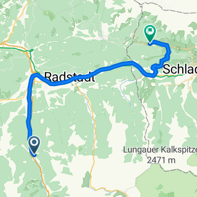
Tourism information center Flachau
Route:
Start at Flachau tourism info - along Flachau village street towards the roundabout at the entrance of Flachau - through the roundabout (second exit) towards Reitdorf - in Reitdorf (after the municipal office) turn right towards Altenmarkt - after the highway underpass (km 5) turn left (towards Atomic company) - at Hotel Kesselgrub turn left over the railway crossing towards Eben - through the village of Eben passing Niedernfritz and Hüttau (Fritztal) to Bischofshofen - after passing through Bischofshofen at the second roundabout turn right towards Mühlbach am Hochkönig - long, partly very steep climb through the village of Hochkönig and the Dientner Sattel towards Dienten - just before the village of Dienten turn left towards Lend - in Lend turn left towards Schwarzach - continue through Schwarzach to St. Johann im Pongau - in St. Johann im Pongau turn right towards Wagrain - steady climb to Wagrain - in the center of Wagrain (right by the church) turn left towards Flachau - final climb back to Flachau
- -:--
- Duration
- 101.9 km
- Distance
- 1,251 m
- Ascent
- 1,251 m
- Descent
- ---
- Avg. speed
- ---
- Max. altitude

Route quality
Waytypes & surfaces along the route
Waytypes
Road
26.5 km
(26 %)
Quiet road
3.1 km
(3 %)
Surfaces
Paved
75.4 km
(74 %)
Unpaved
1 km
(1 %)
Asphalt
75.4 km
(74 %)
Gravel
1 km
(1 %)
Undefined
25.5 km
(25 %)
Route highlights
Points of interest along the route
Point of interest after 45.5 km
Dientner Sattel - 1370 Meter Seehöhe
Drinking water after 101.9 km
Fun & Pro Bikezentrum: geführte Touren, Bikeverleih und -reparatur
Continue with Bikemap
Use, edit, or download this cycling route
You would like to ride Mühlbach - Dienten - Schwarzach or customize it for your own trip? Here is what you can do with this Bikemap route:
Free features
- Save this route as favorite or in collections
- Copy & plan your own version of this route
- Split it into stages to create a multi-day tour
- Sync your route with Garmin or Wahoo
Premium features
Free trial for 3 days, or one-time payment. More about Bikemap Premium.
- Navigate this route on iOS & Android
- Export a GPX / KML file of this route
- Create your custom printout (try it for free)
- Download this route for offline navigation
Discover more Premium features.
Get Bikemap PremiumFrom our community
Other popular routes starting in Flachau
 Altenmarkt - Steinwand - Sattelbauer
- Distance
- 29.2 km
- Ascent
- 1,003 m
- Descent
- 1,003 m
- Location
- Flachau, Salzburg, Austria
 Amadé Radmarathon - B Strecke
- Distance
- 99.5 km
- Ascent
- 0 m
- Descent
- 0 m
- Location
- Flachau, Salzburg, Austria
 EnnsRadweg1
- Distance
- 37.8 km
- Ascent
- 478 m
- Descent
- 342 m
- Location
- Flachau, Salzburg, Austria
 Marbachalmen
- Distance
- 26.1 km
- Ascent
- 352 m
- Descent
- 352 m
- Location
- Flachau, Salzburg, Austria
 Altenmarkt - Königlehen - Radstadt
- Distance
- 28.8 km
- Ascent
- 0 m
- Descent
- 0 m
- Location
- Flachau, Salzburg, Austria
 Runde: Moadörfl Wagrain, Kleinarl Steinkaralm, Jägersee, Wagrain
- Distance
- 47.6 km
- Ascent
- 2,484 m
- Descent
- 2,484 m
- Location
- Flachau, Salzburg, Austria
 Flachau - Marbachalm
- Distance
- 13.1 km
- Ascent
- 375 m
- Descent
- 57 m
- Location
- Flachau, Salzburg, Austria
 Aigenberg
- Distance
- 21.4 km
- Ascent
- 498 m
- Descent
- 498 m
- Location
- Flachau, Salzburg, Austria
Open it in the app