

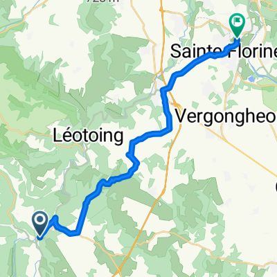
Cézallier Sud
A cycling route starting in Massiac, Auvergne-Rhône-Alpes, France.
Overview
About this route
- -:--
- Duration
- 115.8 km
- Distance
- 1,503 m
- Ascent
- 1,500 m
- Descent
- ---
- Avg. speed
- ---
- Max. altitude
Route quality
Waytypes & surfaces along the route
Waytypes
Road
75.3 km
(65 %)
Quiet road
8.1 km
(7 %)
Surfaces
Paved
4.6 km
(4 %)
Asphalt
4.6 km
(4 %)
Undefined
111.2 km
(96 %)
Route highlights
Points of interest along the route
Point of interest after 22 km
Brèche de Giniol (PD)
Point of interest after 23.2 km
Col de Chanusclade
Point of interest after 28.6 km
Col de la Vazeze
Point of interest after 34.8 km
Col de Fortuniers
Point of interest after 40 km
cascades des Veyrines
Point of interest after 44.2 km
Col de la Malmouche
Point of interest after 51.4 km
Col de la Rieu
Point of interest after 63.1 km
Col de Montirargues
Point of interest after 76.1 km
Col de la Croix de Lampre
Point of interest after 80.5 km
Col de Combalut
Point of interest after 88.3 km
Col du Baladour
Point of interest after 89.4 km
Col de la Croix de Baptiste
Continue with Bikemap
Use, edit, or download this cycling route
You would like to ride Cézallier Sud or customize it for your own trip? Here is what you can do with this Bikemap route:
Free features
- Save this route as favorite or in collections
- Copy & plan your own version of this route
- Split it into stages to create a multi-day tour
- Sync your route with Garmin or Wahoo
Premium features
Free trial for 3 days, or one-time payment. More about Bikemap Premium.
- Navigate this route on iOS & Android
- Export a GPX / KML file of this route
- Create your custom printout (try it for free)
- Download this route for offline navigation
Discover more Premium features.
Get Bikemap PremiumFrom our community
Other popular routes starting in Massiac
 Cézallier Sud
- Distance
- 115.8 km
- Ascent
- 1,503 m
- Descent
- 1,500 m
- Location
- Massiac, Auvergne-Rhône-Alpes, France
 10) Le Pays coupé on edp-parcours.com
- Distance
- 21.8 km
- Ascent
- 483 m
- Descent
- 483 m
- Location
- Massiac, Auvergne-Rhône-Alpes, France
 TDF dg2 47k Saint Flour
- Distance
- 47.3 km
- Ascent
- 776 m
- Descent
- 398 m
- Location
- Massiac, Auvergne-Rhône-Alpes, France
 D 909, Blesle nach Hameau Côte de l'Air, Brassac-les-Mines
- Distance
- 20.8 km
- Ascent
- 358 m
- Descent
- 423 m
- Location
- Massiac, Auvergne-Rhône-Alpes, France
 De La Bessière, Blesle à D246, Mandailles-Saint-Julien
- Distance
- 77.5 km
- Ascent
- 1,727 m
- Descent
- 1,359 m
- Location
- Massiac, Auvergne-Rhône-Alpes, France
 Blesle - Mandailles-Saint-Julien
- Distance
- 74.6 km
- Ascent
- 1,472 m
- Descent
- 1,036 m
- Location
- Massiac, Auvergne-Rhône-Alpes, France
 24-25
24-25- Distance
- 223.5 km
- Ascent
- 576 m
- Descent
- 829 m
- Location
- Massiac, Auvergne-Rhône-Alpes, France
 Fournel weiter Clermont Ferront
- Distance
- 76.4 km
- Ascent
- 675 m
- Descent
- 848 m
- Location
- Massiac, Auvergne-Rhône-Alpes, France
Open it in the app