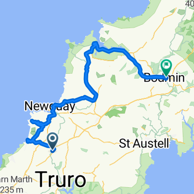
st Agnes
A cycling route starting in Perranporth, England, United Kingdom.
Overview
About this route
- 1 h 4 min
- Duration
- 8.1 km
- Distance
- 141 m
- Ascent
- 157 m
- Descent
- 7.5 km/h
- Avg. speed
- ---
- Max. altitude
Route quality
Waytypes & surfaces along the route
Waytypes
Quiet road
5.7 km
(71 %)
Busy road
2 km
(25 %)
Surfaces
Paved
2.2 km
(28 %)
Asphalt
2.2 km
(28 %)
Undefined
5.8 km
(72 %)
Continue with Bikemap
Use, edit, or download this cycling route
You would like to ride st Agnes or customize it for your own trip? Here is what you can do with this Bikemap route:
Free features
- Save this route as favorite or in collections
- Copy & plan your own version of this route
- Sync your route with Garmin or Wahoo
Premium features
Free trial for 3 days, or one-time payment. More about Bikemap Premium.
- Navigate this route on iOS & Android
- Export a GPX / KML file of this route
- Create your custom printout (try it for free)
- Download this route for offline navigation
Discover more Premium features.
Get Bikemap PremiumFrom our community
Other popular routes starting in Perranporth
- Day 1: St Agnes-Zelah-Hayle
- Distance
- 46 km
- Ascent
- 683 m
- Descent
- 712 m
- Location
- Perranporth, England, United Kingdom
- Perranporth Cycling
- Distance
- 38.3 km
- Ascent
- 603 m
- Descent
- 598 m
- Location
- Perranporth, England, United Kingdom
- Rattler Pro Ride 50 Mile (2018)
- Distance
- 82.4 km
- Ascent
- 1,350 m
- Descent
- 1,351 m
- Location
- Perranporth, England, United Kingdom
- Perranporth Cycling
- Distance
- 35.5 km
- Ascent
- 633 m
- Descent
- 643 m
- Location
- Perranporth, England, United Kingdom
- Fernleigh, Budnic Estate, Perranporth to Failte, Budnic Hill, Perranporth
- Distance
- 15 km
- Ascent
- 190 m
- Descent
- 184 m
- Location
- Perranporth, England, United Kingdom
- Perran Sands Entrance to Perran Sands Entrance
- Distance
- 34.8 km
- Ascent
- 794 m
- Descent
- 794 m
- Location
- Perranporth, England, United Kingdom
- BLue Hil
- Distance
- 32.7 km
- Ascent
- 439 m
- Descent
- 440 m
- Location
- Perranporth, England, United Kingdom
- BLue Hil
- Distance
- 34.6 km
- Ascent
- 532 m
- Descent
- 531 m
- Location
- Perranporth, England, United Kingdom
Open it in the app