

32-CST-Hor-Mait-TJoe-Denn-LSue-LBald-JB-RT-434
A cycling route starting in Oviedo, Florida, United States.
Overview
About this route
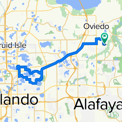
This route goes to Horatio via CST and Tangerine. Then it goes Howell Branch Road, which turns into Horatio at the Maitland city limit.
Instead of proceeding all the way to 17-92, it turns northward through some Residential Neighborhoods (RNs) and goes thru some nice bike lanes and trails. THen it takes Mayo Avenue across Orlando Avenue (17-92) tp Gamewell Avenue. Gamewell goes south thru some RNs and reaches Sybelia Avenue.
From Sybelia, it continues south to a trail that goes to Lake Lilly Park and further south.The trail ends, but it goes thru RNs that straddle Orlando Ave on the west side.
Around REI on Orlando Ave, it crosses it and goes to Denning. m Denning goes south to Mead Garden. There a trail starts and continues south winding around Lake Sue on the west side.
More RNs to Corrine Drive. It minimizes Corrine Drive and goes to Winter Park Road, then to Eastern Parkway headed toward Lake Baldwin while straddling Blue Jacket park.
It goes around Lake Baldwin until it gets to a crosswalk and crosses a RN to get to Cady Way Trail (CDT). AT Baldwin Park Street, it goes east to SR 436, then north to Hanging Moss Road.
On HMR,, it goes to Forsyth, then south a bit, and finally it gets to the Econ Greenway Trail (EGT). It takes EGT all the way into Jay Blanchard Park. This is a beautiful trail.
At the Little Econ dam, it crosses it and goes through a field. Get on the field and go to an entrance to Aelin Road. Ailen goes to Buch Road. From there turn right and go to Rouse, then University Blvd.
Here, I cross University and go to a RaceTrac to refuel with water, then take winding streets to two Siemens parking lots. It goes to Corporate Drive, which going east arrives at SR434 or Alafaya Trail.
Then go north all the way to Alafaya Woods Blvd and finally home.
- -:--
- Duration
- 62.6 km
- Distance
- 84 m
- Ascent
- 82 m
- Descent
- ---
- Avg. speed
- 42 m
- Max. altitude

Route quality
Waytypes & surfaces along the route
Waytypes
Cycleway
20 km
(32 %)
Quiet road
15 km
(24 %)
Surfaces
Paved
28.8 km
(46 %)
Asphalt
24.4 km
(39 %)
Concrete
3.8 km
(6 %)
Continue with Bikemap
Use, edit, or download this cycling route
You would like to ride 32-CST-Hor-Mait-TJoe-Denn-LSue-LBald-JB-RT-434 or customize it for your own trip? Here is what you can do with this Bikemap route:
Free features
- Save this route as favorite or in collections
- Copy & plan your own version of this route
- Sync your route with Garmin or Wahoo
Premium features
Free trial for 3 days, or one-time payment. More about Bikemap Premium.
- Navigate this route on iOS & Android
- Export a GPX / KML file of this route
- Create your custom printout (try it for free)
- Download this route for offline navigation
Discover more Premium features.
Get Bikemap PremiumFrom our community
Other popular routes starting in Oviedo
 36-Hme-Neuro-Kewan-RR
- Distance
- 50 km
- Ascent
- 234 m
- Descent
- 236 m
- Location
- Oviedo, Florida, United States
 06B-Lee-West Oaks Mall
- Distance
- 55.3 km
- Ascent
- 219 m
- Descent
- 200 m
- Location
- Oviedo, Florida, United States
 03-Sect8-SCP-Torcaso-Dys
- Distance
- 48.4 km
- Ascent
- 195 m
- Descent
- 195 m
- Location
- Oviedo, Florida, United States
 01C-Minn-Lee-North-Gilliam-RTrac-436
- Distance
- 51.3 km
- Ascent
- 148 m
- Descent
- 109 m
- Location
- Oviedo, Florida, United States
 10-Barnet-Cinderlane-Bus23
- Distance
- 45.2 km
- Ascent
- 179 m
- Descent
- 175 m
- Location
- Oviedo, Florida, United States
 16C-Barnett-WG-RTrac-105
- Distance
- 61.5 km
- Ascent
- 333 m
- Descent
- 313 m
- Location
- Oviedo, Florida, United States
 38A-SCP-LM-LOB-HGNP-McD
- Distance
- 44.9 km
- Ascent
- 227 m
- Descent
- 234 m
- Location
- Oviedo, Florida, United States
 35-LBald-REI-Interlachen-CWT-CST-McK
- Distance
- 49.6 km
- Ascent
- 25 m
- Descent
- 46 m
- Location
- Oviedo, Florida, United States
Open it in the app