

G. Morcinka Trasa 1
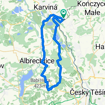
A cycling route starting in Fryštát, Moravskoslezský kraj, Czechia.
Overview
About this route
The more information you write here, the more useful it will be for other users.
- Route progress.
- What is special about this route?
- Why recommend this route?
- What did you like the most here?
- Etc.
- -:--
- Duration
- 17.1 km
- Distance
- 51 m
- Ascent
- 50 m
- Descent
- ---
- Avg. speed
- ---
- Max. altitude

Route quality
Waytypes & surfaces along the route
Waytypes
Quiet road
7.3 km
(43 %)
Track
2 km
(12 %)
Surfaces
Paved
7.7 km
(45 %)
Unpaved
1.5 km
(9 %)
Asphalt
7.3 km
(43 %)
Gravel
1.2 km
(7 %)
Route highlights
Points of interest along the route
Point of interest after 11.5 km
Kościół św.Piotra z Alkantary
Point of interest after 17 km
Continue with Bikemap
Use, edit, or download this cycling route
You would like to ride G. Morcinka Trasa 1 or customize it for your own trip? Here is what you can do with this Bikemap route:
Free features
- Save this route as favorite or in collections
- Copy & plan your own version of this route
- Sync your route with Garmin or Wahoo
Premium features
Free trial for 3 days, or one-time payment. More about Bikemap Premium.
- Navigate this route on iOS & Android
- Export a GPX / KML file of this route
- Create your custom printout (try it for free)
- Download this route for offline navigation
Discover more Premium features.
Get Bikemap PremiumFrom our community
Other popular routes starting in Fryštát
 Karwina > Albrechcice > Hawierzów > Dąbrowa > Karwina
- Distance
- 39.2 km
- Ascent
- 243 m
- Descent
- 246 m
- Location
- Fryštát, Moravskoslezský kraj, Czechia
 Lubomia-Rudy-Racibórz-Tworków
- Distance
- 140.7 km
- Ascent
- 484 m
- Descent
- 484 m
- Location
- Fryštát, Moravskoslezský kraj, Czechia
 karviná - bohumín a zpět
- Distance
- 48.9 km
- Ascent
- 152 m
- Descent
- 152 m
- Location
- Fryštát, Moravskoslezský kraj, Czechia
 Karwina - Stonawa - Górna Sucha - Orłowa - Dąbrowa - Karwina
- Distance
- 33.8 km
- Ascent
- 174 m
- Descent
- 174 m
- Location
- Fryštát, Moravskoslezský kraj, Czechia
 karviná - šilheřovice a zpět
- Distance
- 63.6 km
- Ascent
- 132 m
- Descent
- 132 m
- Location
- Fryštát, Moravskoslezský kraj, Czechia
 okruh - karviná - bohumín
- Distance
- 48.3 km
- Ascent
- 85 m
- Descent
- 85 m
- Location
- Fryštát, Moravskoslezský kraj, Czechia
 Sladami Gustawa Morcinka Trasa 2
- Distance
- 32.7 km
- Ascent
- 132 m
- Descent
- 132 m
- Location
- Fryštát, Moravskoslezský kraj, Czechia
 Na Siedliszcze
- Distance
- 30 km
- Ascent
- 272 m
- Descent
- 272 m
- Location
- Fryštát, Moravskoslezský kraj, Czechia
Open it in the app