

Col du Marchairuz and Col du Mollendruz
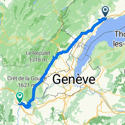
A cycling route starting in Rolle, Canton of Vaud, Switzerland.
Overview
About this route
- -:--
- Duration
- 88.5 km
- Distance
- 1,559 m
- Ascent
- 1,556 m
- Descent
- ---
- Avg. speed
- ---
- Max. altitude

Route quality
Waytypes & surfaces along the route
Waytypes
Road
57.3 km
(65 %)
Busy road
18.7 km
(21 %)
Surfaces
Paved
26.1 km
(30 %)
Asphalt
25.5 km
(29 %)
Paved (undefined)
0.6 km
(<1 %)
Undefined
62.4 km
(70 %)
Route highlights
Points of interest along the route
Point of interest after 20.2 km
Col du Marchairuz
Point of interest after 49.6 km
Col du Mollendruz
Continue with Bikemap
Use, edit, or download this cycling route
You would like to ride Col du Marchairuz and Col du Mollendruz or customize it for your own trip? Here is what you can do with this Bikemap route:
Free features
- Save this route as favorite or in collections
- Copy & plan your own version of this route
- Split it into stages to create a multi-day tour
- Sync your route with Garmin or Wahoo
Premium features
Free trial for 3 days, or one-time payment. More about Bikemap Premium.
- Navigate this route on iOS & Android
- Export a GPX / KML file of this route
- Create your custom printout (try it for free)
- Download this route for offline navigation
Discover more Premium features.
Get Bikemap PremiumFrom our community
Other popular routes starting in Rolle
 Rolle-Marchairuz-Brassus-la Cure-Rolle
- Distance
- 80.4 km
- Ascent
- 1,262 m
- Descent
- 1,262 m
- Location
- Rolle, Canton of Vaud, Switzerland
 Tour de la dôle
- Distance
- 61.7 km
- Ascent
- 1,224 m
- Descent
- 1,224 m
- Location
- Rolle, Canton of Vaud, Switzerland
 Versoix - Valserhône
- Distance
- 70.4 km
- Ascent
- 646 m
- Descent
- 696 m
- Location
- Rolle, Canton of Vaud, Switzerland
 De Rolle à Morges
- Distance
- 35.1 km
- Ascent
- 250 m
- Descent
- 250 m
- Location
- Rolle, Canton of Vaud, Switzerland
 sv 1
sv 1- Distance
- 81.2 km
- Ascent
- 563 m
- Descent
- 472 m
- Location
- Rolle, Canton of Vaud, Switzerland
 Rolle-Meyrin
- Distance
- 38.9 km
- Ascent
- 130 m
- Descent
- 131 m
- Location
- Rolle, Canton of Vaud, Switzerland
 Col du Marchairuz and Col du Mollendruz
- Distance
- 88.5 km
- Ascent
- 1,559 m
- Descent
- 1,556 m
- Location
- Rolle, Canton of Vaud, Switzerland
 Rolle Allaman Aubonne
- Distance
- 17.8 km
- Ascent
- 218 m
- Descent
- 218 m
- Location
- Rolle, Canton of Vaud, Switzerland
Open it in the app