
elc-aus
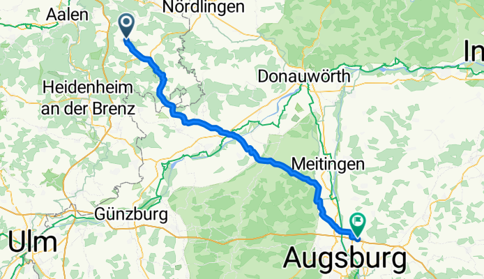
A cycling route starting in Neresheim, Baden-Württemberg, Germany.
Overview
About this route
- -:--
- Duration
- 80.4 km
- Distance
- 183 m
- Ascent
- 321 m
- Descent
- ---
- Avg. speed
- 604 m
- Max. altitude

Route quality
Waytypes & surfaces along the route
Waytypes
Path
27.3 km
(34 %)
Road
22.5 km
(28 %)
Surfaces
Paved
65.7 km
(82 %)
Unpaved
4.5 km
(6 %)
Asphalt
61.2 km
(76 %)
Paved (undefined)
4.4 km
(5 %)
Continue with Bikemap
Use, edit, or download this cycling route
You would like to ride elc-aus or customize it for your own trip? Here is what you can do with this Bikemap route:
Free features
- Save this route as favorite or in collections
- Copy & plan your own version of this route
- Split it into stages to create a multi-day tour
- Sync your route with Garmin or Wahoo
Premium features
Free trial for 3 days, or one-time payment. More about Bikemap Premium.
- Navigate this route on iOS & Android
- Export a GPX / KML file of this route
- Create your custom printout (try it for free)
- Download this route for offline navigation
Discover more Premium features.
Get Bikemap PremiumFrom our community
Other popular routes starting in Neresheim
 N-SD-EDH-Deinigen-NÖ-Utzm-Dorfm-N
- Distance
- 66.9 km
- Ascent
- 457 m
- Descent
- 456 m
- Location
- Neresheim, Baden-Württemberg, Germany
 Härtsfeldrunde
- Distance
- 24.7 km
- Ascent
- 421 m
- Descent
- 421 m
- Location
- Neresheim, Baden-Württemberg, Germany
 Dossinger Tal nach Hãrtsfeldsee
- Distance
- 29.8 km
- Ascent
- 249 m
- Descent
- 256 m
- Location
- Neresheim, Baden-Württemberg, Germany
 Härtsfeldrunde 1003
- Distance
- 44.7 km
- Ascent
- 373 m
- Descent
- 373 m
- Location
- Neresheim, Baden-Württemberg, Germany
 2016 Bayern Tour,Elchingen-Bühlertal-Bühlerzell
- Distance
- 56 km
- Ascent
- 425 m
- Descent
- 641 m
- Location
- Neresheim, Baden-Württemberg, Germany
 Flugplatz
- Distance
- 41.2 km
- Ascent
- 363 m
- Descent
- 423 m
- Location
- Neresheim, Baden-Württemberg, Germany
 Tour Richtung Schnaitheim, Ochsenberg
- Distance
- 33.5 km
- Ascent
- 424 m
- Descent
- 421 m
- Location
- Neresheim, Baden-Württemberg, Germany
 test_neresheim
- Distance
- 22.9 km
- Ascent
- 269 m
- Descent
- 270 m
- Location
- Neresheim, Baden-Württemberg, Germany
Open it in the app