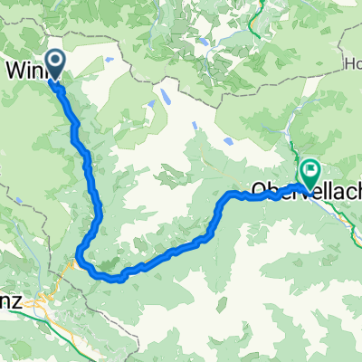
Heiligenblut - Kaiser-Franz-Josefs-Höhe
A cycling route starting in Heiligenblut am Großglockner, Carinthia, Austria.
Overview
About this route
- -:--
- Duration
- 14.6 km
- Distance
- 1,142 m
- Ascent
- 57 m
- Descent
- ---
- Avg. speed
- 2,371 m
- Avg. speed
Route quality
Waytypes & surfaces along the route
Waytypes
Road
11.7 km
(80 %)
Path
1.1 km
(7 %)
Surfaces
Paved
12.8 km
(88 %)
Unpaved
0.6 km
(4 %)
Asphalt
12.8 km
(87 %)
Ground
0.3 km
(2 %)
Continue with Bikemap
Use, edit, or download this cycling route
You would like to ride Heiligenblut - Kaiser-Franz-Josefs-Höhe or customize it for your own trip? Here is what you can do with this Bikemap route:
Free features
- Save this route as favorite or in collections
- Copy & plan your own version of this route
- Sync your route with Garmin or Wahoo
Premium features
Free trial for 3 days, or one-time payment. More about Bikemap Premium.
- Navigate this route on iOS & Android
- Export a GPX / KML file of this route
- Create your custom printout (try it for free)
- Download this route for offline navigation
Discover more Premium features.
Get Bikemap PremiumFrom our community
Other popular routes starting in Heiligenblut am Großglockner
- Heilgenblut - Hochtor - Edelweisspitz - Fusch - Zeller See (část CT2009)
- Distance
- 65.8 km
- Ascent
- 2,442 m
- Descent
- 2,914 m
- Location
- Heiligenblut am Großglockner, Carinthia, Austria
- Fuga 304
- Distance
- 302.5 km
- Ascent
- 793 m
- Descent
- 3,145 m
- Location
- Heiligenblut am Großglockner, Carinthia, Austria
- Großglockner - Millstättersee
- Distance
- 104.6 km
- Ascent
- 803 m
- Descent
- 1,497 m
- Location
- Heiligenblut am Großglockner, Carinthia, Austria
- Rasa
- Distance
- 47.5 km
- Ascent
- 141 m
- Descent
- 726 m
- Location
- Heiligenblut am Großglockner, Carinthia, Austria
- Heiligenblut nach Seeboden am Millstätter See
- Distance
- 92 km
- Ascent
- 1,818 m
- Descent
- 2,492 m
- Location
- Heiligenblut am Großglockner, Carinthia, Austria
- Heiligenblut - Ragga szurdok - Möllbrücke
- Distance
- 76 km
- Ascent
- 132 m
- Descent
- 858 m
- Location
- Heiligenblut am Großglockner, Carinthia, Austria
- Heiligenblut/Mölltalradweg (R8)
- Distance
- 85.7 km
- Ascent
- 504 m
- Descent
- 1,230 m
- Location
- Heiligenblut am Großglockner, Carinthia, Austria
- RR-Berg: Heiligenblut-Edelweissspitze/Grossglockner-Bad Gastein
- Distance
- 96.9 km
- Ascent
- 3,132 m
- Descent
- 3,300 m
- Location
- Heiligenblut am Großglockner, Carinthia, Austria
Open it in the app