

Chambly/St-Jean/Mont St-Grégoire
A cycling route starting in Chambly, Quebec, Canada.
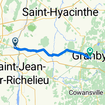
Overview
About this route
- -:--
- Duration
- 52.6 km
- Distance
- 78 m
- Ascent
- 59 m
- Descent
- ---
- Avg. speed
- ---
- Max. altitude
Continue with Bikemap
Use, edit, or download this cycling route
You would like to ride Chambly/St-Jean/Mont St-Grégoire or customize it for your own trip? Here is what you can do with this Bikemap route:
Free features
- Save this route as favorite or in collections
- Copy & plan your own version of this route
- Sync your route with Garmin or Wahoo
Premium features
Free trial for 3 days, or one-time payment. More about Bikemap Premium.
- Navigate this route on iOS & Android
- Export a GPX / KML file of this route
- Create your custom printout (try it for free)
- Download this route for offline navigation
Discover more Premium features.
Get Bikemap PremiumFrom our community
Other popular routes starting in Chambly
 F-S St Hilaire St Grégoire Iberville Chambly
- Distance
- 81.7 km
- Ascent
- 148 m
- Descent
- 147 m
- Location
- Chambly, Quebec, Canada
 Vivace SS Nice Tour 1
- Distance
- 73.6 km
- Ascent
- 112 m
- Descent
- 112 m
- Location
- Chambly, Quebec, Canada
 Chambly vers Granby
- Distance
- 50.4 km
- Ascent
- 154 m
- Descent
- 42 m
- Location
- Chambly, Quebec, Canada
 canal de Chambly
- Distance
- 16 km
- Ascent
- 45 m
- Descent
- 25 m
- Location
- Chambly, Quebec, Canada
 De 1577 Av Bourgogne, Chambly à 3332 Rue des Lucines, St-Hubert
- Distance
- 43.8 km
- Ascent
- 48 m
- Descent
- 32 m
- Location
- Chambly, Quebec, Canada
 Chambly To St-jean
- Distance
- 37.5 km
- Ascent
- 30 m
- Descent
- 30 m
- Location
- Chambly, Quebec, Canada
 VOLTA - Passeio até o Forte Chambly
- Distance
- 25.2 km
- Ascent
- 52 m
- Descent
- 48 m
- Location
- Chambly, Quebec, Canada
 chambly to magog 112
- Distance
- 100.2 km
- Ascent
- 453 m
- Descent
- 259 m
- Location
- Chambly, Quebec, Canada
Open it in the app