

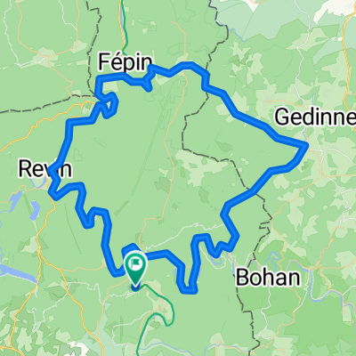
d4 pont sur sambre?
A cycling route starting in Monthermé, Grand Est, France.
Overview
About this route
- -:--
- Duration
- 107.4 km
- Distance
- 593 m
- Ascent
- 593 m
- Descent
- ---
- Avg. speed
- 382 m
- Max. altitude

Route quality
Waytypes & surfaces along the route
Waytypes
Road
48.3 km
(45 %)
Quiet road
27.9 km
(26 %)
Surfaces
Paved
20.6 km
(19 %)
Unpaved
2.5 km
(2 %)
Asphalt
19.6 km
(18 %)
Unpaved (undefined)
1.8 km
(2 %)
Continue with Bikemap
Use, edit, or download this cycling route
You would like to ride d4 pont sur sambre? or customize it for your own trip? Here is what you can do with this Bikemap route:
Free features
- Save this route as favorite or in collections
- Copy & plan your own version of this route
- Split it into stages to create a multi-day tour
- Sync your route with Garmin or Wahoo
Premium features
Free trial for 3 days, or one-time payment. More about Bikemap Premium.
- Navigate this route on iOS & Android
- Export a GPX / KML file of this route
- Create your custom printout (try it for free)
- Download this route for offline navigation
Discover more Premium features.
Get Bikemap PremiumFrom our community
Other popular routes starting in Monthermé
 88 km met een bultje
- Distance
- 88.9 km
- Ascent
- 340 m
- Descent
- 343 m
- Location
- Monthermé, Grand Est, France
 90 km 580m
- Distance
- 91.9 km
- Ascent
- 580 m
- Descent
- 590 m
- Location
- Monthermé, Grand Est, France
 Les HB
- Distance
- 155.7 km
- Ascent
- 2,086 m
- Descent
- 2,105 m
- Location
- Monthermé, Grand Est, France
 Boucle trans-Semoysienne
- Distance
- 58.4 km
- Ascent
- 572 m
- Descent
- 572 m
- Location
- Monthermé, Grand Est, France
 Vieux Moulins 19/x
- Distance
- 155.6 km
- Ascent
- 3,054 m
- Descent
- 3,054 m
- Location
- Monthermé, Grand Est, France
 d4 aa
d4 aa- Distance
- 111.3 km
- Ascent
- 531 m
- Descent
- 517 m
- Location
- Monthermé, Grand Est, France
 Antwerpen - Strasbourg (05)
- Distance
- 50.1 km
- Ascent
- 154 m
- Descent
- 109 m
- Location
- Monthermé, Grand Est, France
 d4 pont sur sambre?
- Distance
- 107.4 km
- Ascent
- 593 m
- Descent
- 593 m
- Location
- Monthermé, Grand Est, France
Open it in the app