Meisenheim-Meisenheim
A cycling route starting in Meisenheim, Rhineland-Palatinate, Germany.
Overview
About this route
- -:--
- Duration
- 112.9 km
- Distance
- 192 m
- Ascent
- 195 m
- Descent
- ---
- Avg. speed
- 277 m
- Max. altitude
Route quality
Waytypes & surfaces along the route
Waytypes
Track
45.2 km
(40 %)
Path
26 km
(23 %)
Surfaces
Paved
94.9 km
(84 %)
Unpaved
11.3 km
(10 %)
Asphalt
75.7 km
(67 %)
Paved (undefined)
19.2 km
(17 %)
Continue with Bikemap
Use, edit, or download this cycling route
You would like to ride Meisenheim-Meisenheim or customize it for your own trip? Here is what you can do with this Bikemap route:
Free features
- Save this route as favorite or in collections
- Copy & plan your own version of this route
- Split it into stages to create a multi-day tour
- Sync your route with Garmin or Wahoo
Premium features
Free trial for 3 days, or one-time payment. More about Bikemap Premium.
- Navigate this route on iOS & Android
- Export a GPX / KML file of this route
- Create your custom printout (try it for free)
- Download this route for offline navigation
Discover more Premium features.
Get Bikemap PremiumFrom our community
Other popular routes starting in Meisenheim
- Meisenheim Kirn
- Distance
- 24.2 km
- Ascent
- 320 m
- Descent
- 286 m
- Location
- Meisenheim, Rhineland-Palatinate, Germany
- Meisenh.Lindenallee | Bad Sobernheim
- Distance
- 16.1 km
- Ascent
- 90 m
- Descent
- 106 m
- Location
- Meisenheim, Rhineland-Palatinate, Germany
- Meisenheim (Hotel Weingut Barth) nach Bad Kreuznach (Brauwerk)
- Distance
- 30.4 km
- Ascent
- 313 m
- Descent
- 365 m
- Location
- Meisenheim, Rhineland-Palatinate, Germany
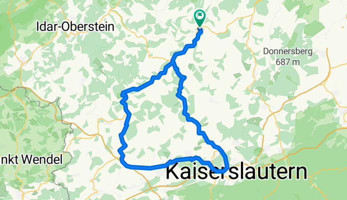
- B420, Meisenheim nach B420, Meisenheim
- Distance
- 43.8 km
- Ascent
- 1,380 m
- Descent
- 1,378 m
- Location
- Meisenheim, Rhineland-Palatinate, Germany
- Glan-Nahe-Moschel-Tour
- Distance
- 63.9 km
- Ascent
- 390 m
- Descent
- 390 m
- Location
- Meisenheim, Rhineland-Palatinate, Germany
- Meisenheim-Meisenheim
- Distance
- 112.9 km
- Ascent
- 192 m
- Descent
- 195 m
- Location
- Meisenheim, Rhineland-Palatinate, Germany
- Draisinentour
- Distance
- 54.6 km
- Ascent
- 187 m
- Descent
- 116 m
- Location
- Meisenheim, Rhineland-Palatinate, Germany
- Meisenheimer Hof - Burg Hotel Obermoschel
- Distance
- 14 km
- Ascent
- 330 m
- Descent
- 234 m
- Location
- Meisenheim, Rhineland-Palatinate, Germany
Open it in the app