

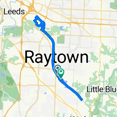
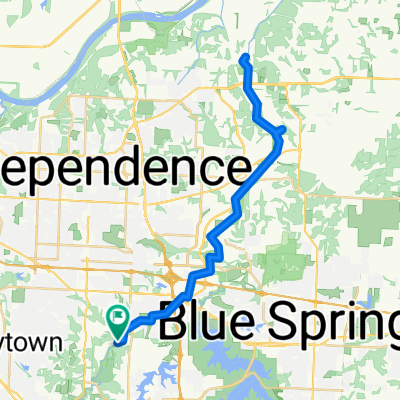
Rock Island Trail (Ph1+2)
A cycling route starting in Raytown, Missouri, United States of America.
Overview
About this route
Riding the Rock Island Trail from Kauffman Stadium to end of the line (south Lee's Summit) and back.
- -:--
- Duration
- 21.5 km
- Distance
- 160 m
- Ascent
- 122 m
- Descent
- ---
- Avg. speed
- 314 m
- Max. altitude

Route quality
Waytypes & surfaces along the route
Waytypes
Cycleway
20.8 km
(97 %)
Pedestrian area
0.5 km
(2 %)
Road
0.2 km
(1 %)
Surfaces
Paved
6.4 km
(30 %)
Unpaved
14.4 km
(67 %)
Gravel
14.4 km
(67 %)
Concrete
6.4 km
(30 %)
Undefined
0.7 km
(3 %)
Continue with Bikemap
Use, edit, or download this cycling route
You would like to ride Rock Island Trail (Ph1+2) or customize it for your own trip? Here is what you can do with this Bikemap route:
Free features
- Save this route as favorite or in collections
- Copy & plan your own version of this route
- Sync your route with Garmin or Wahoo
Premium features
Free trial for 3 days, or one-time payment. More about Bikemap Premium.
- Navigate this route on iOS & Android
- Export a GPX / KML file of this route
- Create your custom printout (try it for free)
- Download this route for offline navigation
Discover more Premium features.
Get Bikemap PremiumFrom our community
Other popular routes starting in Raytown
 Rock Island Trail, Raytown to 6724 Lakeshore Dr, Raytown
- Distance
- 20.2 km
- Ascent
- 251 m
- Descent
- 259 m
- Location
- Raytown, Missouri, United States of America
 6724 Lakeshore Dr, Raytown to 6724 Lakeshore Dr, Raytown
- Distance
- 28 km
- Ascent
- 367 m
- Descent
- 371 m
- Location
- Raytown, Missouri, United States of America
 Lakeshore Drive 6800, Raytown to Lakeshore Drive 6724, Raytown
- Distance
- 24.9 km
- Ascent
- 62 m
- Descent
- 67 m
- Location
- Raytown, Missouri, United States of America
 6724 Lakeshore Dr, Raytown to 6724 Lakeshore Dr, Raytown
- Distance
- 25.9 km
- Ascent
- 389 m
- Descent
- 390 m
- Location
- Raytown, Missouri, United States of America
 East 71 Street 11212, Raytown to East 71 Street 11212, Raytown
- Distance
- 31.6 km
- Ascent
- 88 m
- Descent
- 94 m
- Location
- Raytown, Missouri, United States of America
 6724 Lakeshore Dr, Raytown to 6724 Lakeshore Dr, Raytown
- Distance
- 12.1 km
- Ascent
- 148 m
- Descent
- 150 m
- Location
- Raytown, Missouri, United States of America
 Little Blue Trace Trail, Kansas City to Little Blue Trace Trail, Kansas City
- Distance
- 49.2 km
- Ascent
- 193 m
- Descent
- 193 m
- Location
- Raytown, Missouri, United States of America
 Little Blue Trace Trail
- Distance
- 51.2 km
- Ascent
- 52 m
- Descent
- 54 m
- Location
- Raytown, Missouri, United States of America
Open it in the app